Eloquent Images by Gary Hart
Insight, information, and inspiration for the inquisitive nature photographer
Storm Chasing Diary: “Large Cloud in the Sky”
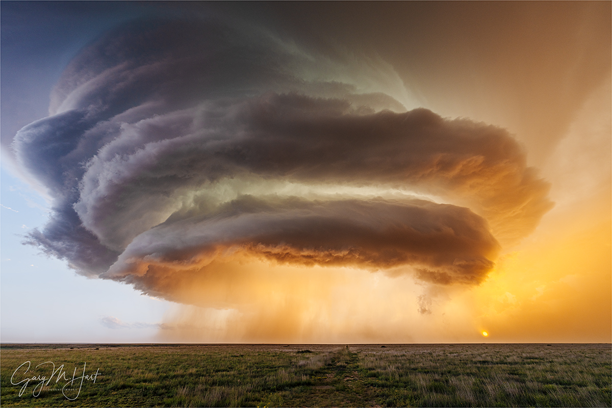
Alien Spaceship, Supercell Near Amistad, New Mexico
Sony α1
Sony 12-24 GM
1/25 seconds
F/9
ISO 100
Because I was traveling and had unreliable connectivity, I started writing this blog in Microsoft Word rather than use the WordPress interface. When I inserted the post’s image at the top of the document, Microsoft’s unsolicited AI description simply said, “Large cloud in the sky.” And while no truer words were ever written, I think a little more context might prove enlightening. So here goes…
You’d think that someone who spends as much time photographing Nature as I do, would at some point cease being surprised by it. I’m here today to disabuse you of that notion.
My primary reason for arranging a Midwest storm chasing trip was to see and photograph a tornado. I simply knew that nothing would be able to top that experience. But just several hours into the trip, I was introduced to my first supercell, literally one of the most beautiful natural sights I’ve ever witnessed. Okay—clearly these trips aren’t just about the tornadoes.
Then, on the third day, after (finally) checking the tornado box (several times), I figured everything after that would be gravy. Wrong again. Because even though we saw no more tornadoes, the magic had only just begun.
While gawking at that day-1 supercell, I distinctly remember telling myself to take a breath and appreciate was I was looking at because I might not see anything this beautiful for the rest of my life. That prediction survived all the way until day-6.
If nothing else, this trip taught me that a supercell is so much more than a very large thunderstorm, it’s a living, breathing entity with a personality and a distinctive lifespan that runs from adolescence to maturity, before inevitably aging out. Achieving supercell status requires a specific combination of atmospheric conditions that cause a conventional cumulous cloud to ascend unchecked into the highest regions of Earth’s troposphere. More than that, a supercell is distinguished from a conventional towering thunderhead, and actually powered by, a rotating convective updraft: a mesocyclone. No mesocyclone, no supercell.
The key atmospheric ingredients necessary to create a mesocyclone are*:
- Atmospheric moisture (humidity): Moisture in the atmosphere provides the latent energy that sustains a thunderstorm’s updrafts.
- Unstable (buoyant) air: The warmer a “package” of air (picture a cube of air of any size), the more water vapor (moisture in gas form) it can hold. Air temperature is the measure of molecular energy; since air becomes less dense as it rises, it naturally cools because it has fewer molecules. Cooler air can hold less water vapor than warmer air, so a package of air that’s heated by the sun (the reason most thunderstorms form in the afternoon, when the sun is highest and warmest) rises and cools. Eventually the rising air cools to a temperature that can no longer hold its contained water vapor, forcing it to condense into liquid, and a cloud forms. Condensation creates heat, so as long as the condensation creates enough heat to keep the rising air warmer than the surrounding air, the updraft will continue.
- Wind shear: Wind shear is wind that travels in different directions at different elevations. When rising, unstable air encounters wind shear, it starts rotating. This rotation tilts the updrafts and downdrafts at the mesocyclone’s core, allowing them to persist independently, without interfering with each other.
* This is not me pretending to be an expert, this is me trying to learn something by researching and writing about it. (No AI was used, so any error is mine alone.)
The sensory manifestations of all the atmospheric machinations necessary to form a mesocyclone are truly (cliché alert) breathtaking: Massive, towering, symmetrical cloud layers; explosive (often seemingly ubiquitous) lightning, some of it intra-cloud, some of it cloud-to-ground (CTG), and its associated thunder; torrential rain (or no rain at all, depending on your position beneath the storm); vivid blue or blue-green regions in the clouds that reveal the supercell’s hail core; a distinct roar as the hail approaches; winds that range from nonexistent potentially hurricane force—airflow feeding the storm’s updraft rushes toward its center, while the storm’s downdraft “exhaust” flows away; rapidly rotating clouds at different elevations, sometimes, but not always, dropping to the ground in the form of a tornado. Experienced storm chasers (i.e., not me), read all of these features, combine combine their observations with the virtually realtime radar and atmospheric data provided by NOAA, and somehow determine the best location to safely view and photograph with storm-whisperer sagacity.
The story of this image
Basking in our day-4 tornado success, our day-5 chase brought another nice supercell and some lightning, but nothing that rivaled our prior sights (admittedly, our standards had been raised significantly). Shortly after noon on day-6, we departed our prior night’s hotel in Lubbock and motored northward through a collection of tiny Texas Panhandle “towns” (often not much more than a church, gas station, and cafe surrounded by a sprinkling of small houses). As with every other chase day, our tour director and meteorologist Chris Gullikson rode shotgun in the lead van, constantly monitoring the (rapidly improving) atmospheric conditions, giving us in the trailing van a play-by-play over the CB. Somewhere west of Amarillo, he identified our target storm and strategized a plan of attack.
In Dalhart, Texas we bent west, toward New Mexico. Chris’s CB updates to our trailing van became more frequent and excitement-tinged: “Tops at 52 (thousand feet)”; “3-inch hail marker”; “Tops at 55,” and so on. We’d learned early in the trip that clouds that stretched above 50,000 feet were especially promising—the higher the better. Similarly, we learned that the larger the hail (determined, it seems, by radar information), while a great indicator of an active supercell, also factored into our route choice—hail much larger than golf-ball-sized risks damaging the van, as well as any chaser who might be outside.
At this point in our tour, Chris’s late afternoon chase-declarations had become fairly routine, so while we were excited by a cell’s potential, we knew that data alone doesn’t ensure success. But soon we were in the thick of the storm, battling rain and hail, and dodging lightning to get in position. At one point we navigated hail that deposited a 2-inch layer on the road.
We’d get out front of the storm, pull the vans over, and everyone would pile out—if Chris’s first command was, “No tripods,” we knew this would be a quick stop—then hustle back when a sudden wind signaled the imminent arrival of rain or hail. Relatively close lightning became fairly routine, but at no point did I ever feel unsafe. (I asked Chris about this later, and learned that he has a pretty good idea of where in the storm the lightning will strike—but he did add that those estimations are far from certain.)
I knew we were on a pretty cool supercell, but had no idea what was in store until the lead van braked without the usual advance CB notice and Chris hustled everyone out with far more urgency that usual. He said, “We really don’t have time to stop here, but you just have to see this! No tripods!”
To this point, virtually every field we passed on this trip was completely fenced, forcing us to stop at the barbed wire just a few feet from the road, and often contend with drainage ditches and power lines in our foreground. But this time we found ourselves at an opening in the fence that allowed us to walk about 100 feet into the field, providing a clear view at the spectacle unfolding in the sky.
Even the experienced storm chasers, including Chris, admitted that this was one of the most magnificent supercells they’ve ever witnessed. But as if that wasn’t enough, the setting sun’s golden disk had burned through the low clouds on the horizon, sending shafts of sunlight skyward to illuminate the clouds’s underside.
With my 12-24 lens as wide as it would go (and still barely able to fit this massive beast), I had time to click 10 frames in fairly rapid succession before I a heard a faint roar coming from just down the road, in the direction from which we’d just come. The roar intensified and while I puzzled about what it could be, Chris yelled with the most urgency I’d heard all trip, “HAIL! Back in the vans now!” Everyone bolted for the opening in the fence, bottlenecking there as the first pellets pelted us. Supercell hail is nothing to mess with, and even these relatively small (grape-size) samples stung. Once through the fence, we loaded in record time and screeched away before the larger stuff reached us, everyone still in complete awe of the beauty we’d just witnessed.
You’d think that this beautiful supercell would be the (non-tornado) highlight of the trip, but it wasn’t even the highlight of the day. But that’s a story for another day…
Join me in a future storm chasing workshop
Workshop Schedule || Purchase Prints || Instagram
Nature’s Best Moments
Click any image to scroll through the gallery LARGE


")


")


")


Gary, your description captured both the science and the emotions of storm chasing. That supercell put on one of nature’s best shows.
Wow, that’s an incredible shot!
Pingback: Looking Back at 2025: I Was There | Eloquent Images by Gary Hart