Eloquent Images by Gary Hart
Insight, information, and inspiration for the inquisitive nature photographer
Danger in Paradise
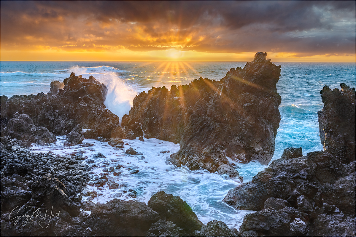
Sunrise, Laupahoehoe Point Sunstar, Hawaii
Sony a7R V
Sony 24-105 f/4 G
ISO 100
f/18
1/13 seconds
Battered for millennia by earthquakes, floods, volcanic eruptions, and tropical cyclones, it’s no wonder Hawaii’s residents keep one eye on the ocean, the other on the mountains—all while closely monitoring the sky overhead. I’ve visited each of Hawaii’s major islands many times (okay, so technically, on Oahu I haven’t been outside the airport, which is its own sort of disaster), and have personally experienced a veritable smorgasbord of these natural events. (Yet somehow I keep returning—go figure.)
The Hawaii earthquakes I’ve felt have been relatively minor jiggles to my earthquake-hardened California bones, but each served as a reminder that Hawaii has a history of large earthquakes, with magnitudes at least into the high 7s. Active volcanism makes the Big Island particularly vulnerable: as recently as 2018 it was shaken by a magnitude 6.9 earthquake; in 1975 a magnitude 7.7 quake rocked the Puna Coast just south and west of Hilo. Moving north, the Hawaiian Islands’ earthquake risk decreases: Maui has experienced a couple of magnitude 6 quakes in historic times (just offshore), while Oahu only gets a moderate jostling from time to time (but does get a pretty good jolt from the strongest Big Island quakes)—only Kauai, the oldest island, is (relatively) seismically stable.
Hawaii’s volcanoes are sexier than its earthquakes, actually attracting visitors (you don’t see too many people rushing toward an earthquake). I missed the recent Mauna Loa eruption, but have witnessed numerous Kilauea eruptions, in many forms: many time I’ve enjoyed standing on the rim at night to view the glow and smoke emanating from the lava lake bubbling just out of sight on the caldera floor far below; last year, I stood on the edge of (the recently seismically remodeled) Kilauea caldera with my workshop group and peered down at dozens of towering lava fountains less than a mile away. In 2010, Don Smith and I hiked close enough to a Kilauea lava flow that we felt its heat and heard trees explode. But despite their dramatic aesthetic appeal, Hawaii’s volcanoes are still too powerful to be taken lightly. While most of its eruptions lack the explosiveness of many more dangerous volcanoes around the world, as recently as 2018 Hawaii’s effusive lava flows have wiped out entire towns, destroying hundreds of homes on their way to the ocean.
And then there are the tropical cyclones that lash the islands several times each decade. By far the most significant storm damage to a Hawaiian island was inflicted by Hurricane Iniki in 1992, striking Kauai as a Category 4 storm with winds up to 140 miles per hour. While I’ve never experienced anything that extreme on my visits, in September of 2018, each of my two workshops was altered by a different hurricane: first on the Big Island when, a few days before that workshop started, a close brush with Category 5 Hurricane Lane deposited up to 58 inches of rain that flooded many of my locations. I departed Hawaii for Maui and my second workshop, only to have Hurricane Olivia (downgraded to a tropical storm just before landfall) force me to relocate the workshop’s two nights in Hana, and find replacement locations for those days.
I’ve also learned firsthand that it doesn’t take a hurricane to generate floods in Hawaii. In 2016 I was on Maui when just regular old torrential rainfall caused a 500-year flood in the Iao Valley and Central Maui, destroying homes and swamping cars. While driving through Central Maui after the water receded, I saw cars still mired in water to their doors.
Even given this history of disasters, compounded by my own personal experience with some of Hawaii’s most extreme natural elements, I would argue that Hawaii’s greatest natural risk is tsunamis. Despite their relative rarity, tsunamis have killed more people than all other Hawaiian natural disasters combined. The islands’ position smack in the middle of the Pacific Ring of Fire, which happens to be the source of nearly 3/4 of Earth’s tsunamis, means Hawaiians need to think in terms of when, not if, the next tsunami hits, and plan accordingly.
Unlike conventional waves, which are wind-generated and affect only the ocean’s surface, a tsunami is formed when a cataclysmic event displaces water from the ocean surface all the way down to the ocean floor. Potential ocean-moving events include submarine landslides, volcanic eruptions, and meteor impacts. But by far the most frequent force behind a tsunami is subduction earthquakes, when one tectonic plate thrusts beneath another and displaces the overlying plate and all the water above it.
In the simplest terms possible, the energy of an ocean wave is the product of its amplitude (maximum height) and wavelength (the distance between amplitudes). In the open ocean, with deep water and no obstructions, a tsunami’s energy is almost entirely committed to spreading outward at 400-600 miles per hour (around the speed of a commercial airliner). At those speeds, a tsunami’s wavelength could be 100 miles, with amplitudes of a foot or two. In fact, with an open ocean amplitude of just a foot or so, when a tsunami passes beneath a boat, the boat’s occupants feel nothing.
But as a tsunami approaches land, it starts dragging on the ocean floor, eventually slowing to around 30 miles per hour. Since the next waves in line are still racing through open ocean at hundreds of miles per hour, when the wave in front of them slams on the brakes, water begins piling up as most of the forward energy is suddenly transformed into wave-building energy: A massive wave is born.
As we’ve seen in recent, and not so recent, history, the power and suddenness of a tsunami can be catastrophic. The Indian Ocean tsunami of 2004 killed over 230,000 people, some as far away as 3,000 miles. The 2011 Japan tsunami killed 10,000 people in Japan, and was directly responsible for the meltdown at the Fukushima nuclear power plant. (It also caused some minor damage in Hawaii, among other places.)
Hawaii’s long tsunami history includes many small and moderate events, and a handful that can be labeled major (and tragic). Since the beginning of the 20th century, three especially significant tsunamis stand out:
- April 1, 1946: Generated by a magnitude 8.5 in the Aleutian Islands, this tsunami is considered as Hawaii’s most significant for the 159 lives it took, and the major damage dealt to every Hawaiian island.
- May 23, 1960: Generated by a magnitude 9.5 earthquake near Chile—the largest earthquake ever measured and more than 30 times stronger than the 1946 Aleutian earthquake. Despite the lessons of 1946, many lives were lost by Hilo residents who didn’t heed warnings.
- November 29, 1975: Generated by a magnitude 7.7 earthquake south of Hilo. on the east flank of Kilauea—though its damage was mostly limited to Hawaii’s southeast coast, this tsunami arrived too quickly following the quake for its victims to flea to safety.
I’m reminded of Hawaii’s tsunami history each time I visit Laupahoehoe Point on the Big Island’s east coast. This is where the 1946 tsunami took the lives of 24 residents, including 16 students and 5 teachers who were waiting at the local schoolhouse for school to start. Adding to the tragedy, warnings of the approaching peril were ignored as April Fools’ Day jokes.
Based on the inexplicable inability to warn people thousands of miles, and many hours, from the tsunami’s source, the US Tsunami Warning Center was formed. Another response to this tragedy was the significant upgrade of local building practices. For example, the 8-story Hilo Hawaiian Hotel, where my Big Island workshops are based, is right on Hilo Bay (you could literally hit the water with a rock from our balconies) and potentially ground-zero for the next tsunami. Constructed in 1975 atop (extremely reinforced) concrete columns, significant sections of the Hilo Hawaiian’s bottom two floors are completely open to the elements, with no walls on either side, designed specifically to allow any large wave to sweep right through rather than push against the structure. Throughout Hilo are tsunami warning sirens that are tested once each month, and evacuation routes are clearly signed.
In 2015 I actually got a firsthand look at how seriously tsunamis are taken in Hilo when, while there for a workshop, a magnitude 8.3 earthquake near Chile triggered a Pacific tsunami warning. Fortunately, today’s satellite technology and ocean buoy network enables much better tsunami tracking than was available in 1946 and 1960, so not only did we get many hours notice, by the time the wave reached Hawaii it was measured in inches and the warning had been long suspended (and I enjoyed a peaceful sleep rather than spending the night in an evacuation shelter).
About this image
Sunrise, Laupahoehoe Point Sunstar, Hawaii
In most of my workshops, our first sunrise is at Laupahoehoe Point. Before we start, I emphasize to my group the location’s tsunami history, and point out some of the tsunami damage still visible. In fact, the location where we photograph is just a few hundred feet from the location of the teachers’ cottages that were swept away in the 1946 tsunami.
You may (or may not) notice that I have several very similar images of this scene. That’s partly because it in fact provides a very nice composition that I always enjoy photographing, but mostly because we’re at Laupahoehoe at the beginning of the workshop, making it especially important that I stay tethered to my group. Which means the variety I get at Laupahoehoe Point is more about conditions than compositional inspiration.
This morning was especially nice for a couple of reasons: first, recent hurricane near-misses had seriously stirred up the Hawaiian surf; second, getting a break in the clouds right on the horizon isn’t especially common in Hawaii. Seeing the opening this morning, I was able to anticipate the opportunity for a nice sunstar and believed I was ready for it.
Unfortunately, I made a couple of mistakes because I’d spent most of the morning working with my group. The first was that I thought I was using my 16-35 f/2.8 lens that provides a much better sunstar than the 24-105 f/4 lens I was actually using. The second mistake was forgetting to remove the ND filter I’d been using earlier in the morning to smooth the waves. After helping people in my group prepare for their sunstar opportunity, I rushed to my camera and started clicking as soon as the sun appeared, realizing with the first click that I’d need to wait out the 20-second exposure my camera had started. Fortunately, it all worked out, and I was actually able to get a couple of frames like this one, capturing the instant of an explosive wave’s impact.
At the risk of stating the obvious, another thing I want to point out is how hard it is to photograph directly into the sun. When I got around to processing this image at home, not only did I have serious dynamic range problems to deal with, I also had tons of nasty lens flare blobs to clean up. Fixing lens flare was mostly just a tedious process with the Remove tool; the dynamic range was a matter of processing the sky and foreground separately. Since I no longer use graduated neutral density filters, and I never blend multiple exposures, my margin for exposure error was extremely small, but by monitoring my histogram and pushing my highlights to the limits of recoverability when I captured the image, I ended up with shadows that still contained enough clean detail to work with.
Workshop Schedule || Purchase Prints || Instagram
Lots More Sunstars


")


