Eloquent Images by Gary Hart
Insight, information, and inspiration for the inquisitive nature photographer
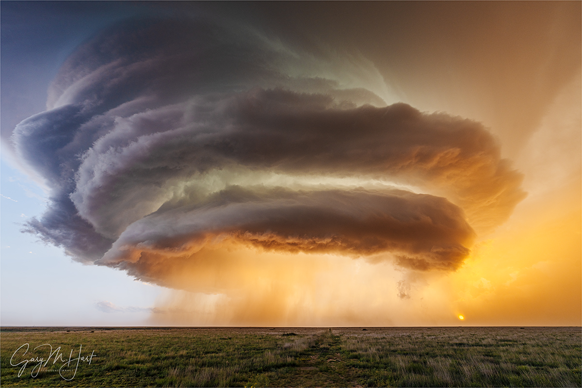
Storm Chasing Diary: Saving the Best For Last
Posted on July 27, 2025

Sunset Supercell Lightning, Amistad, New Mexico
Sony a7R V
Sony 24-105 f/4 G
ISO 50
f/18
1/4 second
I’ve really enjoyed sharing my storm chasing images and experiences with everyone here on my blog, but need to end this “Storm Chasing Diary” series so I can return to some the unprocessed images from other recent trips. So the “last” referred to in the title is the series, not the images, which will keep coming as time permits.
“Best” is a very subjective term. I can’t even decide for sure that this image is the best one I captured this day, but I’m going with it because at the very least, it was the most thrilling.
After finishing with the storm cell I wrote about in my previous blog—the one with the double rainbow split by a lightning bolt, I looked around, wondering where everyone had gone. A minute ago we were all-in on the rainbow, but now I was alone. No, they weren’t playing a trick on me, they were lined up on the road about 100 feet away, aiming their cameras the other direction, toward a storm that had organized into a massive supercell while I was off chasing rainbows.
Surveying that scene, I said aloud and to no one in particular, “Well, this looks interesting,” then ambled off to join them. Surely I wouldn’t be able to top what I’d just captured, so on the way I stopped to share my excitement over capturing a double rainbow with a lightning bolt with our trip leader, Chris Gullikson. As I prepared to pull up the image on the back of my camera, a lightning bolt like none I’d ever seen froze me. This electric monster stretched from the base of the new supercell’s anvil—a thunderstorm’s cap, where the convection ceases and the clouds spread horizontally—all the way to the ground, instantly infusing me with deeper understanding of why everyone was so focused on this new storm. (Not to mention a renewed sense of urgency.)
This lightning was on a completely different scale from the ones I’d just been photographing—certainly in intensity, but even more impressive (and unprecedented in my personal history) was its length. The storm’s anvil topped out over 50,000 feet above the ground, and though the anvil’s top wasn’t visible from down on the ground, the bolt I’d just seen must have spanned several vertical vertical miles before stabbing the ground only about a mile away.
I quickened my pace (okay, sprinted), found a slot in the group’s already established firing line, and hastily set up. Since my Lightning Trigger was already attached and ready to go, all I need to do was compose and re-meter. To this point, most of my supercell images had used a 12-24 or 16-35 lens—wide enough to include the entire structure. But both were back in the van and I didn’t want to take my eyes off the storm to go fetch them if I didn’t need to. So I twisted my 24-105 all the way out to 24mm, and found it was just wide enough to include all of the most important components of the scene: the wall cloud, the rain curtain and sun, plus a little of the road. Though the cell was moving pretty rapidly from right to left, I reasoned I could stick with the 24-105 as long as I monitored my composition and adjusted for the motion every minute or two. Then I crossed my fingers, hoping that my composition would reach high enough to include all of whatever lightning I saw.
With everything ready for the next lightning strike, I took the time to appreciate the view. Of course every supercell is spectacularly beautiful, but this one was made even more special by its proximity to the sun, which etched its glowing disk in the dense rain curtain, and infused the backlit the clouds with a rich, golden hue. Surely, I thought, adding a lightning bolt like the one I just saw to something already so beautiful would be too much to ask for.
Apparently not. While I’ve seen many storms dispense more lightning than this one, the emphasis here was clearly on quality over quantity. In the 30 or so minutes I photographed it, I captured 6 bolts of similar brilliance and length to that first one. The one I’m sharing here was not only the evening’s strongest, eliciting the most ooohs and ahhhs from the group, it was also the most perfectly positioned, making it an easy to choice to be the first to process. I eventually went back and processed a couple of others as vertical frames, partly to add variety, and partly because they were just too beautiful to let languish on a hard drive.
If you’d have told me before the storm chasing workshop that we’d have one day where we saw multiple tornadoes, but that our best day would be a day with zero tornadoes, I wouldn’t have believed you. But if someone held a gun to my head and told me to pick one “best” day of the storm chasing trip, I’d have to say (before disarming them and rendering them unconscious, of course) this day would be the one.
June 7, 2025, Near Amistad, New Mexico (processed so far)


It’s days like this one, as well as our nearly as memorable tornado day, that remind me why I am a nature photographer. The unpredictability of the natural world, combined with its absolute insistence on doing exactly what it wants to do, can make photographing it an extremely frustrating endeavor. But then we get rewards like this.
One other thing this whole storm chasing experience did for me was reinforce my message to people who tell me how lucky I am to live in California, where I have so much world class beauty right at my doorstep. And while I can’t disagree (or complain!), I remind them that California skies are generally quite boring. The atmospheric sights I witnessed were every bit as spectacular as any more permanent terrestrial feature I’ve witnessed. Which is why I’m jealous of anyone who lives somewhere that serves up skies like this from time-to-time. Fortunately, until I return, I have the bounty I collected on this trip, both processed and yet-to-be processed, to keep me happy. So while this may be the last of my “Storm Chasing Diary” series, it absolutely won’t be the end of new images from this trip.
I’m also excited to say that this experience so greatly exceeded my expectations in so many ways (far beyond the photography itself, believe it or not), that I’ve decided to continue doing (this thing that was supposed to be a one-off) on into the future. In fact, Jeremy Woodhouse and I have already scheduled a storm chasing workshop for next summer, and are in the planning stages for another one in 2027.
Join me on another storm chasing adventure next summer
The Joy of Lightning
Click any image to scroll through the gallery LARGE


Storm Chasing Diary: “Large Cloud in the Sky”
Posted on June 18, 2025
Alien Spaceship, Supercell Near Amistad, New Mexico
Sony α1
Sony 12-24 GM
1/25 seconds
F/9
ISO 100
Because I was traveling and had unreliable connectivity, I started writing this blog in Microsoft Word rather than use the WordPress interface. When I inserted the post’s image at the top of the document, Microsoft’s unsolicited AI description simply said, “Large cloud in the sky.” And while no truer words were ever written, I think a little more context might prove enlightening. So here goes…
You’d think that someone who spends as much time photographing Nature as I do, would at some point cease being surprised by it. I’m here today to disabuse you of that notion.
My primary reason for arranging a Midwest storm chasing trip was to see and photograph a tornado. I simply knew that nothing would be able to top that experience. But just several hours into the trip, I was introduced to my first supercell, literally one of the most beautiful natural sights I’ve ever witnessed. Okay—clearly these trips aren’t just about the tornadoes.
Then, on the third day, after (finally) checking the tornado box (several times), I figured everything after that would be gravy. Wrong again. Because even though we saw no more tornadoes, the magic had only just begun.
While gawking at that day-1 supercell, I distinctly remember telling myself to take a breath and appreciate was I was looking at because I might not see anything this beautiful for the rest of my life. That prediction survived all the way until day-6.
If nothing else, this trip taught me that a supercell is so much more than a very large thunderstorm, it’s a living, breathing entity with a personality and a distinctive lifespan that runs from adolescence to maturity, before inevitably aging out. Achieving supercell status requires a specific combination of atmospheric conditions that cause a conventional cumulous cloud to ascend unchecked into the highest regions of Earth’s troposphere. More than that, a supercell is distinguished from a conventional towering thunderhead, and actually powered by, a rotating convective updraft: a mesocyclone. No mesocyclone, no supercell.
The key atmospheric ingredients necessary to create a mesocyclone are*:
- Atmospheric moisture (humidity): Moisture in the atmosphere provides the latent energy that sustains a thunderstorm’s updrafts.
- Unstable (buoyant) air: The warmer a “package” of air (picture a cube of air of any size), the more water vapor (moisture in gas form) it can hold. Air temperature is the measure of molecular energy; since air becomes less dense as it rises, it naturally cools because it has fewer molecules. Cooler air can hold less water vapor than warmer air, so a package of air that’s heated by the sun (the reason most thunderstorms form in the afternoon, when the sun is highest and warmest) rises and cools. Eventually the rising air cools to a temperature that can no longer hold its contained water vapor, forcing it to condense into liquid, and a cloud forms. Condensation creates heat, so as long as the condensation creates enough heat to keep the rising air warmer than the surrounding air, the updraft will continue.
- Wind shear: Wind shear is wind that travels in different directions at different elevations. When rising, unstable air encounters wind shear, it starts rotating. This rotation tilts the updrafts and downdrafts at the mesocyclone’s core, allowing them to persist independently, without interfering with each other.
* This is not me pretending to be an expert, this is me trying to learn something by researching and writing about it. (No AI was used, so any error is mine alone.)
The sensory manifestations of all the atmospheric machinations necessary to form a mesocyclone are truly (cliché alert) breathtaking: Massive, towering, symmetrical cloud layers; explosive (often seemingly ubiquitous) lightning, some of it intra-cloud, some of it cloud-to-ground (CTG), and its associated thunder; torrential rain (or no rain at all, depending on your position beneath the storm); vivid blue or blue-green regions in the clouds that reveal the supercell’s hail core; a distinct roar as the hail approaches; winds that range from nonexistent potentially hurricane force—airflow feeding the storm’s updraft rushes toward its center, while the storm’s downdraft “exhaust” flows away; rapidly rotating clouds at different elevations, sometimes, but not always, dropping to the ground in the form of a tornado. Experienced storm chasers (i.e., not me), read all of these features, combine combine their observations with the virtually realtime radar and atmospheric data provided by NOAA, and somehow determine the best location to safely view and photograph with storm-whisperer sagacity.
The story of this image
Basking in our day-4 tornado success, our day-5 chase brought another nice supercell and some lightning, but nothing that rivaled our prior sights (admittedly, our standards had been raised significantly). Shortly after noon on day-6, we departed our prior night’s hotel in Lubbock and motored northward through a collection of tiny Texas Panhandle “towns” (often not much more than a church, gas station, and cafe surrounded by a sprinkling of small houses). As with every other chase day, our tour director and meteorologist Chris Gullikson rode shotgun in the lead van, constantly monitoring the (rapidly improving) atmospheric conditions, giving us in the trailing van a play-by-play over the CB. Somewhere west of Amarillo, he identified our target storm and strategized a plan of attack.
In Dalhart, Texas we bent west, toward New Mexico. Chris’s CB updates to our trailing van became more frequent and excitement-tinged: “Tops at 52 (thousand feet)”; “3-inch hail marker”; “Tops at 55,” and so on. We’d learned early in the trip that clouds that stretched above 50,000 feet were especially promising—the higher the better. Similarly, we learned that the larger the hail (determined, it seems, by radar information), while a great indicator of an active supercell, also factored into our route choice—hail much larger than golf-ball-sized risks damaging the van, as well as any chaser who might be outside.
At this point in our tour, Chris’s late afternoon chase-declarations had become fairly routine, so while we were excited by a cell’s potential, we knew that data alone doesn’t ensure success. But soon we were in the thick of the storm, battling rain and hail, and dodging lightning to get in position. At one point we navigated hail that deposited a 2-inch layer on the road.
We’d get out front of the storm, pull the vans over, and everyone would pile out—if Chris’s first command was, “No tripods,” we knew this would be a quick stop—then hustle back when a sudden wind signaled the imminent arrival of rain or hail. Relatively close lightning became fairly routine, but at no point did I ever feel unsafe. (I asked Chris about this later, and learned that he has a pretty good idea of where in the storm the lightning will strike—but he did add that those estimations are far from certain.)
I knew we were on a pretty cool supercell, but had no idea what was in store until the lead van braked without the usual advance CB notice and Chris hustled everyone out with far more urgency that usual. He said, “We really don’t have time to stop here, but you just have to see this! No tripods!”
To this point, virtually every field we passed on this trip was completely fenced, forcing us to stop at the barbed wire just a few feet from the road, and often contend with drainage ditches and power lines in our foreground. But this time we found ourselves at an opening in the fence that allowed us to walk about 100 feet into the field, providing a clear view at the spectacle unfolding in the sky.
Even the experienced storm chasers, including Chris, admitted that this was one of the most magnificent supercells they’ve ever witnessed. But as if that wasn’t enough, the setting sun’s golden disk had burned through the low clouds on the horizon, sending shafts of sunlight skyward to illuminate the clouds’s underside.
With my 12-24 lens as wide as it would go (and still barely able to fit this massive beast), I had time to click 10 frames in fairly rapid succession before I a heard a faint roar coming from just down the road, in the direction from which we’d just come. The roar intensified and while I puzzled about what it could be, Chris yelled with the most urgency I’d heard all trip, “HAIL! Back in the vans now!” Everyone bolted for the opening in the fence, bottlenecking there as the first pellets pelted us. Supercell hail is nothing to mess with, and even these relatively small (grape-size) samples stung. Once through the fence, we loaded in record time and screeched away before the larger stuff reached us, everyone still in complete awe of the beauty we’d just witnessed.
You’d think that this beautiful supercell would be the (non-tornado) highlight of the trip, but it wasn’t even the highlight of the day. But that’s a story for another day…
Join me in a future storm chasing workshop
Workshop Schedule || Purchase Prints || Instagram
Nature’s Best Moments
Click any image to scroll through the gallery LARGE


")


")


")


Storm Chasing Diary: My First Tornado
Posted on June 9, 2025

First Tornado, Lingo, New Mexico
Sony a7R V
Sony 24-105 f/4 G
ISO 200
f/16
1/40 second
Everyone remembers their first time. For me, the experience was as thrilling as I’d imagined, but only lasted about a minute. (I’m talking about my first tornado—what did you think I meant?)
For as long as I can remember, I’ve wanted to see a tornado. Over the years this desire has intensified to the point where a tornado is quite probably my most frequent dream subject. When the NWS suggests just the slightest possibility of rotating thunderstorms in Northern California, I scan the skies and sometimes have even been known to hop in my car to go tornado hunting. (California averages one tornado per year.)
Gary’s Bucket List:
- See a tornado
Raft Grand CanyonRainbow over Yosemite ValleyNaked-eye cometNorthern Lights
Even though a tornado sighting has been number one on my list as all the items below it have fallen away, the opportunity has always eluded me. I suspect it has something to do with an approach based on simply waiting for the tornado to come to me—probably not a winning strategy in California. This year, I decided to change that.
On the recommendation of one of my frequent workshop students, I connected with Jeremy Woodhouse, a fellow photographer and photo workshop leader, who for the last several years has assembled storm chasing tours for photographers. Partnering with Tempest Tours out of Arlington, Texas, Jeremy has put his groups on the scene of some of the Midwest’s most extreme weather. I reached out to Jeremy and told him, if he assembled a storm chasing trip, I’d fill it, and a storm chasing collaboration was born.
In my previous post, I wrote about our first day and the incredible supercell we witnessed. No tornado, but no complaints. But still…
Day-two was quiet—a welcome respite after the initial day’s intensity and miles. We drove from Kansas, through Oklahoma, before finally settling down in Amarillo—without changing plans once. The highlight of that day was dinner at The Big Texan (home of the “free” 72 ounce steak)—trust me, you have to experience this place firsthand to appreciate it. Though there wasn’t much weather happening on day-two, the decision to be in Amarillo wasn’t random—it was to position ourselves for the next day’s chase, which looked far more promising.
In our day-three morning weather briefing (we start each day with a detailed discussion of the day’s weather from our tour-leader/meteorologist, Chris), we learned that the atmosphere was setting up beautifully for supercell development, not just that day, but also over the next three days (at least). We spent most of that afternoon bouncing around New Mexico and West Texas, where we saw lots of rain, hail, beautiful clouds, and (spectacular) lightning, but no tornado. We spent that night back in Amarillo.
Each day Chris identifies a general region to target, based on the morning’s forecast—not the general weather forecast we all get from our weather apps, websites, and TV weatherman, this is extremely detailed atmospheric data from NOAA, with technical analysis that can only be evaluated and subjectively interpreted by an expert. In the day-four briefing, Chris told us conditions were even better than the prior day’s. But despite the promising prospects, the rest of the morning unfolded with little sense of urgency. That’s because the big storms develop from mid-afternoon into the evening, so we generally don’t need to head out on a chase until late morning or early afternoon.
Once we do get on the road, there’s usually a lot of driving around, looping, and backtracking. While Jeremy drives the lead van, Chris rides shotgun and keeps a constant eye on his computer, phone, and ceiling-mounted real-time radar monitor. With every weather update, he further refines our target zone. I ride shotgun in the trailing van; in addition to answering whatever photo question might come up in our van, I provide an essential DJ service (classic rock, anyone?). Our two vans use CBs to stay in touch, and Chris frequently updates Tom, the driver of the trailing van and an experienced storm chaser himself, on all weather changes and other pertinent information.
Words cannot express how fast these supercells explode from a run-of-the-mill thunderstorm into a violent, roiling tower. So, in addition to interpreting weather data, experienced storm chasers must read, on the fly, dynamic features in these building cells (rotation, outflow and inflow, updrafts and downdrafts, to name a few) to determine the supercell’s next move. Once the cell’s direction of motion, speed, growth is established, Chris positions the group as close as possible to the action without subjecting everyone to the inevitable lightning and large hail, not to mention any tornado that might form. No small feat by itself, but factor in the swarm of other chasers seeking similar advantages, and it’s no wonder mayhem ensues whenever a supercell develops.
Once you establish which cell has the best potential to develop into a supercell, merely getting close is not enough. Each supercell has a mind of its own, a unique personality that seems to relish defying expectations. Some have the potential to drop tornadoes, while others might be better lightning producers, or possess spectacular (photogenic) structure (don’t forget your 12mm). Which of these traits you want to go for will determine where to set up to view and photograph.
Ideally we can get out in front of the storm and let it come to us, or better still, watch it move laterally across our view. But a couple of times we’ve had to “punch through the core,” an absolutely thrilling E-ticket ride that includes buckets of rain, punishing hail (and potentially car damaging or even life threatening), and a barrage of simultaneous lightning and thunder.
As you might imagine, the trip leader’s navigation skills are key (the rest of us just follow blindly), as is his ability to think quickly and decisively, and an ability to change plans mid-execution. Terrain is relatively flat in the rural areas we’ve concentrated on so far, with few trees, and lots of agriculture. The network of roads is pretty good, though many are rough and narrow, and often transition to dirt with little notice. Agriculture rules out here, but we also see a lot of livestock (no flying cows so far), and pass numerous oil rigs and wind turbines, vestiges of energy’s past and harbingers of energy’s future, often in very close proximity.
Despite possessing all the elements necessary to spark malevolent competition (crowds, passion, and urgency), the storm chasing community seems to be quite collegial. And despite the challenging roads, everyone seems work well together (creative parking skills help).
Even though the sky was completely overcast as we motored south from Amarillo toward Lubbock—not a good sign, as you need sun to kick-off the all important convection—this was apparently expected, and Chris seemed pretty excited by the atmospheric data he was seeing.
After a few feints and dodges, we ended up tracking south and east toward the most promising region near the Texas, New Mexico border. Apparently we weren’t the only ones who could interpret this cryptic atmospheric data, because it wasn’t long before we started encountering other chasers. Soon it felt like a storm chasing convention—they just kept coming.
By the time we reached ground-zero in eastern New Mexico, our target cell was well into adolescence and on its way to adulthood. We poked around its perimeter a bit, and at one point tried to get closer, then executed a hasty retreat when Chris (somehow) sensed the potential for damaging hail just down the road.
We were no longer on a casual drive, we were in full-on chase mode. We pivoted back the way we came and, looking for anything to put in the foreground of our images, returned to a field of hay bales we’d passed ten minutes earlier.
This gave us a great view of the developing wall cloud (lowering cumulus base from which a tornado usually forms) from a relatively safe distance (maybe a mile or so?). We were close enough to see that it was rotating, and Chris started shouting that a tornado could be imminent.
And then, there it was—a black funnel descending from the cloud base, stretching Earthward. Someone shouted, “It’s on the ground!”, and we were in business.
My first tornado. I just clicked like crazy, and even managed to catch a brief video with my iPhone. Within a minute or so, the funnel was already ascending back where it came from; it vanished shortly thereafter. This was not the last tornado we saw this day, nor was it the most impressive—not even close. But it was my first, and I’ll never forget it.
Gary’s Revised Bucket List:
See a tornadoRaft Grand CanyonRainbow over Yosemite ValleyNaked-eye cometNorthern Lights
Workshop Schedule || Purchase Prints || Instagram
More Wild Weather


, Yosemite")


Storm Chasing Diary: Hit the Ground Running
Posted on June 6, 2025
 Supercell and Lightning, Northeast Colorado
Sony α1
Sony 12-24 GM
.4 seconds
F/14
ISO 50
What would you think if I told you that, on my 12-day storm chasing trip in the Midwest, we drove from Colorado, to Wyoming, to Nebraska, back to Colorado, back to Nebraska, and finally to Kansas? Pretty nuts, right?
Please don’t judge me when I tell you all that was just our first day. But when crazy weather is your subject, lots of miles and crazy hours are not negotiable. Fortunately, our storm chasing leaders did give us a small break on day-two, when we started in Kansas and finished the day in Texas, via Oklahoma. As I write this, it’s day-three and I’m sitting in one of our two vans in Vaughn, New Mexico, waiting with my group for our trip-leader/meteorologist to decide whether to stay put with the current storm, head northwest toward an active storm near Albuquerque, or motor east to Fort Sumner to take advantage of increasingly favorable conditions there. (Note: We ended up with, “None of the above.”)
Day-one (Monday) was my first-ever storm chasing experience, and saying we hit the ground running would be an understatement. After a morning orientation at our Denver hotel that included introductions and a lecture that seemed designed specifically to satisfy my inner weather geek, all 16 of us (me, our tour-guide/meteorologist, my co-leader and driver Jeremy Woodhouse, our other driver, and the 12 photographers/chasers comprising the workshop group) piled into our two 12-passenger vans and pointed northeast. Within a couple of hours we were on a storm in southeastern Wyoming, where I got to photograph my first-ever supercell. But spectacular as that was, we didn’t stay long, because (apparently) a better storm was blooming back in Colorado.
After leaving Wyoming, the rest of our day was filled with so much, I don’t have the memory or time to provide blow-by-blow specifics. We’d be racing to get in position for a brewing storm, then see something too good to pass and make an unscheduled brake-slam/hop-out/click/retreat stop, before continuing on our way. Plan changes were routine and came faster than I could keep up.
The weather only intensified as the afternoon progressed. Near Merino, Colorado, we finally got out in front of a storm, enabling us to settle down long enough for the tripods to come out. I set up up with my Sony a1 and 12-24 f/2.8 lens—the only lens wide enough to capture the entire cell as it bore down on us. When I realized how much lightning was firing (mostly to the right of the cell), I quickly attached my Lightning Trigger and went all the way out to 12mm to maximize my lightning chances.
The plan to follow my standard compose/click/evaluate/refine/click workflow went right out the window when I saw how quickly the storm was moving (right-to-left and approaching). Since I needed to be at 12mm, horizontal, with the supercell centered to include all of it, there wasn’t much opportunity to add variety to my compositions. My Lightning Trigger was clicking my camera so rapidly, at bolts seen and unseen, I adopted a new strategy: just let the Lightning Trigger handle the clicking, while I stood back and absorbed the spectacle. My only job was to monitor my exposure and occasionally reframe to account for the storm’s movement. I even had time to capture some video with my iPhone while my grown-up camera did the real work.
This storm actually displayed enough rotation that we thought it might dispense a tornado, and at one point we even heard a tornado siren, but no such luck. Most of its lightning was intra-cloud and out of my frame, but rather than recompose for lightning shots, I kept my composition on the star of the show: the supercell. Though the scene that afternoon was really about this truly magnificent storm, I was thrilled to find a few frames accented with squiggles of lightning.
That night we finished shooting in Nebraska (I think) with a different cell that generated several tornado alerts on our phones (picture a van with 8 people receiving slightly out of synch tornado warnings), but we never saw one. We finally rolled into our hotel in Goodland, Kansas at around 11 p.m., too late for dinner—a not uncommon experience, I’ve learned.
It’s now day-5 and soooooo much has happened since then. And we still have a week to go. No guarantees, but I’ll try to post occasional updates as time permits. Stay tuned….
Join Me On An Upcoming Storm Chasing Adventure
Workshop Schedule || Purchase Prints || Instagram
Cloud Collection
Click any image to scroll through the gallery LARGE


, Death Valley")


