Eloquent Images by Gary Hart
Insight, information, and inspiration for the inquisitive nature photographer
If it’s Tuesday, this must be Bishop
Posted on September 30, 2014

Bristlecone Moonrise, Patriarch Grove, White Mountains, California
Canon EOS-1Ds Mark III
60 mm
.3 seconds
F/11
ISO 100
I have no one to blame but myself (a significant downside of being self-employed), and know I’m not going to get a lot of sympathy, but I just need to share how crazy my last few weeks have been. I’m in the final third of a stretch of three photo workshops in three time zones in three weeks, separated by a grand total of 20 hours at home.
Today I’m in Bishop, California, for day-two of my Eastern Sierra workshop that started yesterday in Lone Pine (California) and wraps up Friday morning in Lee Vining (California). This marathon travel schedule kicked-off on Thursday, September 12, when I left Sacramento for my Hawaii Big Island workshop. I finished that workshop with a Kilauea night shoot on Friday the 19th; Saturday morning I was back to the Hilo airport for my flight home (plane change and layover in Honolulu), finally dragging in the front door about 11 p.m. Saturday night.
At 8:00 a.m. Sunday morning my daughter deposited me back at the Sacramento airport for a flight to Salt Lake City, where I met Don Smith for the five-hour drive to Jackson Hole to help Don with his Grand Tetons workshop. Because the Hawaii/Wyoming weather conditions are so different, and my turnaround was so quick, I actually packed for the Teton before leaving for Hawaii (I’m so glad I did).
After a week in the Tetons, we wrapped up that workshop with a wet sunrise shoot on Saturday morning—then it was straight to the Jackson airport for a series of flights and airport shuttle that got me home Saturday night. I had just enough time to upload my images, refresh my suitcase, catch five hours sleep, and pack the car before heading back out the door early Sunday morning for the six-hour drive to Lone Pine for my Eastern Sierra workshop.
Am I tired? Probably, but I won’t feel it until my drive home on Friday. Am I complaining? Absolutely not. Not only did I do this to myself, how could anyone complain about three weeks filled with Hawaii, the Grand Tetons, and the Eastern Sierra?
And honestly, you can’t really be happy doing what I do without at least being able to tolerate travel. This year, before my current marathon travel stretch, I’ve been to Death Valley, Yosemite (many times), Maui, Kauai, the Grand Canyon three times (including a raft trip), plus Page and Sedona. And truth be told, I enjoy driving, and don’t mind flying. Driving relaxes me, and flying is an opportunity to catch up on my reading and writing. Nevertheless, it will be nice to have consecutive days home, in my own bed,with the alarm off—before next month’s trip to the Columbia River Gorge….
A little more about the Eastern Sierra and this image
Everyone knows about Hawaii, and most know about the Grand Tetons, but mention of the Eastern Sierra still elicits a blank stare from many people. That’s probably because most tourists haven’t discovered it yet (the photographers certainly have). With Mt. Whitney and the Alabama Hills (if you’ve ever seen a John Wayne, Gary Cooper, or John Ford western, you know the Alabama Hills), the bristlecone pines (in the White Mountains, across the Owens Valley from the Eastern Sierra), Mono Lake, Yosemite’s Tuolumne Meadows, and lots of fall color, it’s my most diverse photo workshop.
We started yesterday evening with a nice shoot of the Whitney Portal waterfall, in the shadow of Mt. Whitney. This morning we photographed alpenglow on Mt. Whitney and the Sierra crest from Whitney Arch (aka, Mobius Arch) in the Alabama Hills. After breakfast we made the easy, scenic one hour drive to Bishop, which is where I am now (thank you, Starbucks). Tonight it’ll be the bristlecone pines, at more than 4,000 years, among the oldest living things on Earth (older even than Larry King!).
For tonight’s bristlecone shoot I’ll take the workshop to the relatively accessible Schulman Grove. But when I’m on my own, I often continue thirteen unpaved miles to the Patriarch Grove. And that’s the trip I made a few years ago, because I thought the bristlecones would make a nice foreground for the rising full moon, and because the Patriarch Grove has a clearer view of the eastern horizon than the Schulman Grove.
At the Patriarch Grove, finding the clear view I wanted required me to take off cross-country. Unfortunately, when I scaled the final ridge, I found the horizon obscured by clouds. Not to worry, the light was perfect for photographing these weather-worn, gnarled trees. I’m usually pretty good about catching the moon’s appearance, but because I’d written it off for this evening (shame on me), I failed to register that the clouds were breaking up. Which is why I was both surprised and pleased to find the moon’s glowing disk hovering just above the clouds a few minutes after sunset.
I’d been wandering so much, and so focused on the nearby scene, that I hadn’t identified a particular tree for any potential moon shot (also shame on me). With very little time before the foreground/moon contrast became un-photographable, I felt quite fortunate to find this tree so quickly. A wide composition would have shrunk the moon to nearly invisible, so I stepped back as far as the terrain allowed so I could zoom closer and compress the separation (and enlarge the moon a little). With a vertical composition, I had to decide on rocks or sky, but it wasn’t hard to decide that foreground rocks were far more interesting than empty sky.
Let’s see, what’s tomorrow? Wednesday. Lee Vining, here I come….
An Eastern Sierra gallery
Click an image for a larger view, and to enjoy the slide show


Let’s all take a breath and step away from the ledge
Posted on September 26, 2014

Tree at Sunset, McGee Creek Canyon, Eastern Sierra
Canon EOS-1Ds Mark II
1/40 second
F/7.1
ISO 400
126 mm
National Forest Service commercial photography policy (it’s not as bad as you think)
I’ve received a number of inquiries (some quite panicked) in the last few days asking my opinion about the “new” National Forest Service policy regarding commercial photography. I’ve actually read some media accounts that imply that simply whipping out your iPhone and snapping a mountain lake risks a $1,000 fine. After doing a little research, I’ve confirmed that this is yet one more example of the media whipping the public into a frenzy by selecting a few facts and presenting them in the most sensational way. Here’s an example: http://www.esquire.com/blogs/news/1000-dollar-fine-for-pictures-in-the-forest.
Not being an expert on the subject, I can’t really say whether there are any factual errors in that article. But I can say that it’s a pretty self-serving (he’s certainly received a lot of attention) distortion of the actual policy I found posted on the National Forest Service website (http://www.fs.usda.gov/Internet/FSE_DOCUMENTS/stelprdb5355613.pdf). Here’s the excerpt from the NFS document that applies to me and my photography:
“Still Photography: A special use permit is required for activities on National Forest System lands when the purpose is to: (1) Promote or advertise a product or service using actors, models, sets, or props that are not part of the site’s natural or cultural resources or administrative facilities; or (2) Create an image for commercial sale by using sets or props. In addition, a permit may be required if no activities involving actors, models, sets, or props are proposed when: (1) The activity takes place in an area where the general public is not allowed; or (2) In situations in which the Forest Service would incur additional administrative costs to either permit or monitor the activity.“
As far as I’m concerned, this policy doesn’t sound unreasonable, nor does it sound like my livelihood is in imminent peril, and I’m pretty sure no one’s photographic life is jeopardized.
As someone who conducts 10-12 photo workshops each year, I’m a strong advocate for reasonable rules and restrictions that protect the natural resources that are the foundation of my business (and my mental health). I have no problem jumping through all the necessary hoops—liability insurance, first aid certification, group size, and so on—and paying the annual fees (usually in the $200-$250 range) that each workshop location’s permit process requires. I also find the people I deal with at these locations to generally be quite helpful, reasonable to deal with, not to mention downright flexible when a unique situation arise (like the time I overlooked an application deadline and didn’t discover my error until the last minute).
It’s interesting that this issue should arise right now, as I’m in Grand Tetons National Park helping Don Smith with his photo workshop here. The talk around town is about a moose that had to be put down a couple of days ago when she broke her leg after being spooked by a horde of overzealous wildlife photographers. It’s a rare trip that I don’t witness photographers do illegal or foolish things that imperil themselves (not to mention the lives of those who would need to rescue them), frighten or threaten wildlife, and damage the fragile ecosystem. It’s this very small minority of selfish and/or ignorant photographers who put all photographers in a bad light, leaving National Park and Forest authorities no choice but to implement tighter regulation. I’ve spoken up and intervened at times, but I often regret the times that I just shook my head and walked away after witnessing something I knew to be wrong.
So. Would I support the kind of heavy-handed National Forest Service regulations that the media implies is coming our way? Absolutely not. And while I don’t think something like that is imminent, I do wish photographers would do a better job of policing themselves, both by managing their own behavior, and by respectfully speaking up when another photographer behaves irresponsibly before we’re all affected by more restrictive policy and stricter enforcement.
About this image
What better way to demonstrate my lack of concern by posting this image from Inyo National forest. This tree on the dirt road to McGee Creek had been on my radar for several years, but I’d never found the conditions suitable to photograph it. But following an afternoon fall color shoot at the creek, the vestiges of sunset lit these tilde-shaped clouds. I knew exactly where I wanted to be but wasn’t sure I had time to get there. I raced down the road, pulled my truck to the side, and had time for just a couple of frames before the color faded.
A National Forest Gallery


Addition by subtraction
Posted on September 22, 2014
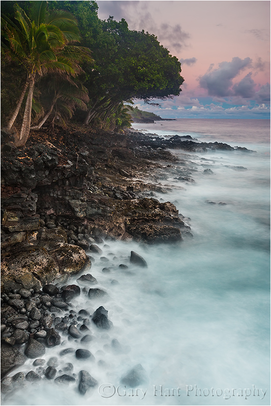
Sunset on the Rocks, Puna Coast, Hawaii
Canon EOS-5D Mark III
29 mm
8 seconds
F/16
ISO 200
In my previous blog post I mentioned that I lost a couple of my Hawaii locations to Hurricane Iselle. Not only was the loss no big deal, it proved a catalyst that jarred me from my rut and into more exploring.
This location was at first glance an exposed, twenty foot cliff above the Pacific with a great view up the Puna Coast, past palm trees and surf-battered, recently cooled lava. But, as with most spots, there’s a lot more if you take the time to look. Exploring the dense growth lining the coast here soon brought me to views of tiered, reflective pools. While getting these views required a little bushwhacking followed by some creative rock-hopping, I know if I were by myself, that’s where I’d have ended up. But when leading a group I need to be more careful—it’s one thing when I injure myself doing something stupid, and something entirely different to guide others into risky spots.
Each group is different when it comes to risk taking—in this case when I offered to guide the group toward the pools I’d found the previous day, only two followed, so I returned to the rock platform where everyone seemed quite content with the spectacular view—the rocks and pools will wait for another visit. And while everyone may have missed a few photo opportunities on the safety of our cliff, not only did we still get some great stuff, we were in close enough proximity that laughter abounded (all without missing a click, of course).
About twenty feet below us, large waves sent explosions of spray skyward; occasionally a perfect coincidence of wave and wind dusted the group with a fine mist that was more refreshing than soaking. Our view here was northeast, which meant the setting sun was more or less behind us. By this, our final sunset, everyone had started to understand why I say my favorite sunrise/sunset view is usually away from the sun. Not only is the light easier to manage in that direction, the Earth-shadow paints the post-sunset (or pre-sunrise) horizon with rich pink and blue hues that the camera can reveal long after they’ve faded to the eye.
The best views were straight up the coast, so I quickly decided a vertical composition was the way to go here. I experimented with different shutter speeds to vary the blur in the waves, but as the scene darkened, each blur became some variation of extreme motion blur. The other major variable in the scene was how wide to compose. With a large tree overhanging the rocks toward the back of the scene, including lots of foliage proved better than truncating everything but the protruding crown of that one tree.
I captured this frame about five minutes after sunset. Giving the scene enough light to bring out detail in the shaded, dark-green foliage without washing out the color in the sky, I employed a two-stop hard-transition Singh-Ray graduated neutral density filter. Instead of the standard GND horizontal orientation, I turned it vertically, aligning the transition with the coastline. To mask the transition, I vibrated the filter slightly left/right throughout the entire eight-second exposure. Smoothing the tones in Lightroom/Photoshop became quite simple, thanks to the GND at capture.
My periodic rounds during our shoot seemed to indicate that everyone was happy—this in spite of a couple of extreme drenchings at the hands of two large waves that far exceeded all that had preceded it to land squarely atop those on the southeast corner of our perch—but it wasn’t until someone exclaimed at the end of the shoot, “This is the best spot yet!” that I knew I’d found a keeper. My former (“lost”) locations were nice, but it was good to be nudged into remembering that unknown opportunities are usually just a little exploration away.
Upcoming Hawaii workshops
Maui Tropical Paradise (two nights in West Maui, two nights in Hana), March 2-6, 2015
Hawaii Big Island Volcanos and Waterfalls, September 14-18, 2015
A Hidden Hawaii Coast Gallery
Click an image for a larger view, and to enjoy the slide show


One eye on the ocean, the other on the volcano
Posted on September 16, 2014
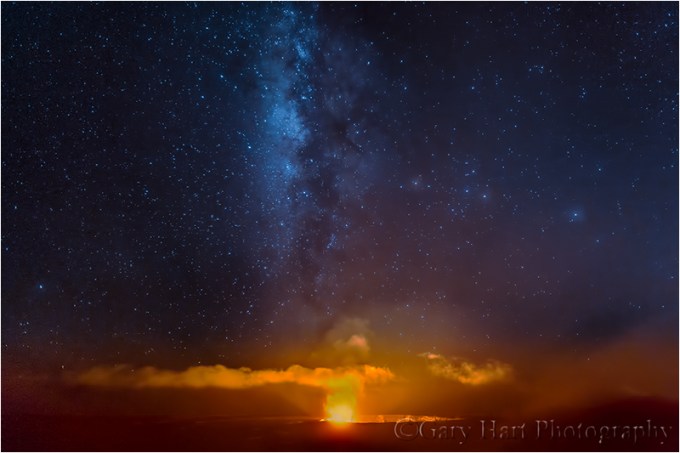
Heavenly Fire, Kilauea Caldera, Hawaii
Canon EOS-5D Mark III
16mm
10 seconds
F/16
ISO 3200
September 16, 2014
It’s easy to envy residents of Hawaii’s Big Island—they enjoy some of the cleanest air and darkest skies on Earth, their soothing ocean breezes ensure that the always warm daytime highs remain quite comfortable, and the bathtub-warm Pacific keeps overnight lows from straying far from the 70-degree mark. Scenery here is a postcard-perfect mix of symmetrical volcanoes, lush rain forests, swaying palms, and lapping surf. I mean, with all this perfection, what could possibly go wrong?
Well, let me tell you….
Last month Tropical Storm Iselle, just a few hours removed from hurricane status, slammed Hawaii’s Puna Coast with tree-snapping winds and frog-drowning rain that cut electricity, flooded roads, and disrupted many lives for weeks. Touring the area in and around Hilo, it’s easy to appreciate Hawaiian resilience—thanks to quick action, hard work, and continuous smiles, most visitors would find it difficult to believe what happened here just a month ago. But on the drive south of Hilo along the Puna Coast, I witnessed firsthand Iselle’s power in its aftermath. There beaches have been rearranged beyond recognition and entire forests have been leveled.
But despite its impact, Iselle is already old news. This month residents of Hawaii’s Puna region have done a 180, turning their always vigilant eyes away from the ocean and toward the volcano. In late June Kilauea’s Pu`u `O`o Crater dispatched a river of lava down the volcano’s southeast flank. Since Pu`u `O`o has been erupting continuously since 1983, this latest incursion didn’t initially raise many eyebrows. But the flow has persisted, advancing now at about 250 yards per day. While this isn’t “Run-for-your life!” speed, it’s more like high stakes water torture because there’s very little that can be done to stop, slow, or even deflect the lava’s inexorable march. Residents of the communities of Kaohe and Pahoa can do nothing but watch, pray, and prepare—if the volcano persists, they’re wiped out. Not only that, the lava flow also threatens the Pahoa Highway, currently the only route in and out for the thousands of residents of the Puna region.
Recent reports of increased activity on Muana Loa have also notched up the anxiety. Lava from its last eruption, in 1984, threatened Hawaii’s capital, Hilo, before petering out with just a few miles to spare. Because Muana Loa eruptions tend to be larger and more explosive than Kilauea eruptions, any increased activity there is taken very seriously.
Had enough? Well, there’s more thing: With its funnel-shaped bay and bullseye placement in the Pacific Ring of Fire, Hilo is generally considered the most tsunami vulnerable city in the world. Fatal tsunamis have struck the Big Island in 1837, 1868, 1877, 1923, 1946, 1960, and 1975. Yesterday my photo workshop group photographed sunrise at Laupahoehoe Point, where damage from the most deadly tsunami to strike American soil is still visible. That tsunami, in 1946 (before Hawaii became a state), traveled 2,500 miles from the Aleutian Islands to kill 159 Hawaiians, including 20 schoolchildren and 4 teachers in Laupahoehoe.
Despite this shopping list of threats and hardship, I don’t get the sense the Hawaiians want sympathy. Despite the unknown but potentially devastating consequences facing them, both imminent and potential, no one here is feeling sorry for themselves. There’s much talk about the current lava flow that will directly or indirectly impact every resident of the Big Island’s Hilo side, but no hand-wringing—life goes on and smiles abound. Indeed, everyone here seems to have sprung into action in one way or another, shoring up old long abandoned roads (the jungle claims anything left unattended with frightening speed), helping people move possessions to safe ground, offering temporary shelter, and whatever else might help.
The Aloha spirit is alive and well, and I have no doubt that it will persevere in the face of whatever adversity Nature throws at them.
About this image
My Hawaii photo workshop began Monday afternoon, but my brother and I arrived on the Big Island on Friday because I hate doing any workshop without first running all my locations to make sure there are no surprises. And this time it turned out to be a wise move—not only did I get a couple of extra days in paradise, I did indeed encounter surprises, courtesy of Iselle, when I discovered two of my go-to locations rendered inaccessible by storm damage. I spent Saturday searching for alternatives and by Saturday’s end had a couple of great substitute spots. That night we celebrated with a night shoot on Kilauea. (I was going to visit Kilauea anyway, but if I’d still been stressing about my locations, I probably wouldn’t have been in the right mindset to photograph.)
We arrived to find the Milky Way glowing brightly above the caldera and immediately started shooting. Because I don’t have as many horizontal compositions of the caldera as vertical, I started horizontal. By the time I’d captured a half dozen or so frames, a heavy mist dropped into the caldera to quickly obscure the entire view (one more example of our utter helplessness to the whims of Nature).
In this frame I went quite wide, not only to capture as much of the Milky Way as possible, but also to include all of the thin cloud layer painted orange by the light of the caldera’s fire. This is a single click (no blending of multiple images), though I did clone just a little bit of color back into the hopelessly blown center of the volcano’s flame.
A Kilauea Gallery
Click and image for a larger view, and to enjoy the slide slow


Ticket to paradise
Posted on September 11, 2014

Hawaii Sunrise, Puna Coast, Big Island
Canon 1Ds Mark III
35mm
1 second
F/16
ISO 100
Tomorrow I head off to the Big Island for my annual workshop there. Not a bad gig.
One of the great things about Hawaii is the fact that there is no such thing as a private beach—all beaches are open to everyone. Of course that doesn’t give tourists carte blanche to do as they please, and some locals can be pretty territorial about “their” beaches. But I’ve found that if you treat the beaches with respect (leave it as you found it, or better), honor the many areas of spiritual significance (don’t go traipsing through burial grounds and religious sites), and don’t disturb the locals (use your inside voice), most Hawaiians are quite happy to share their beautiful coast and lush rain forests.
Unlike the smooth beaches and gentle surf of the Big Island’s Kona side, the Hilo side is bounded by rugged, volcanic beaches—not great for swimming, but fantastic to photograph. It’s this way because Kilauea has been in some degree of activity for many centuries, and most of this volcanic activity is focused on the Puna Coast south and west of Hilo. The result is pretty much ubiquitous black rock and sand like you see here.
Driving the narrow road that follows the Puna Coast is one of my favorite things to do on the Big Island—on every visit I “discover” another hidden gem (or two) like this. I found this anonymous beach while exploring one afternoon a couple of years ago, and rose early the next morning to get out there for sunrise. Many Hawaii sunrises and sunsets have clouds all the way down to the horizon, but on this morning, much to my delight, the rising sun found its way through a gap in the clouds.
One more thing I love about Hawaii? Well, there’s the ability to photograph sunrise in a tank top, shorts, and flip-flops. Can’t wait….
A Big Island Gallery
(Click an image for a closer look, and to enjoy the slide show)


")


Nuts and bolts at the Grand Canyon
Posted on September 4, 2014

Too Close, Twin Lightning Bolts, North Rim, Grand Canyon
Canon EOS-5D Mark III
24-105L
1/8 second
F/18
ISO 100
The bolts started around 1:15; the nuts showed up about ten minutes later. There were 14 of us. We were stationed on the outside viewing deck of the Grand Canyon Lodge on the North Rim, tripods, cameras, and lightning triggers poised and ready for action. The “action” we were ready for was lightning, and more specifically, the opportunity to photograph it.
The storm had started fairly benignly, poking at South Rim a comfortable distance away, far enough in fact that we heard no thunder. But as often happens, we became so caught up in the intensifying pyrotechnics that we failed to appreciate how much our sky was darkening and that the bolts were in fact landing closer. We continued in exhilarated ignorance until a tripod-rattling thunderclap and simultaneous white flash returned us to the reality of the moment. Hmmm.
By the time the raindrops started plopping, the lightning show had reached such a crescendo that we found all kinds of rationalizations for persistence in the face of potential death: “I think it’s moving west of us,” or, “The lodge’s lightning rods will protect us,” or, “If it were really that dangerous, the hotel staff would make us leave.” (Ummm: When the strikes are that close, it doesn’t matter where the storm is heading; lightning rods are to protect the (smart) people inside the lodge; the hotel staff isn’t paid enough to go outside for anything that risky.) I wish I could say it was common sense that eventually drove us all inside, but the reality is that when the heavy rain finally arrived, it became impossible to keep the front of our lenses dry.
So what is it about danger that brings out the stupid in photographers? I used to be able to use the “I’m from California and we don’t get lightning so I don’t know any better,” defense, but that won’t fly anymore because I do know better: I know a lightning strike can be fatal, and those who survive are often left with a life-long disability; I know that lightning can hit 10 miles from its last strike; I know that if you can hear the thunder, you’re too close.
And it’s not just lightning that brings out the stupid. While chasing potential shots, I know of a photographer who scaled a cliff far beyond my his skill level, drove without hesitation into (but not out of) a raging creek, and became hopelessly mired in mud on a narrow jungle track. And we’ve all read news reports about the photographer plummeting to her death while angling for a better view, or of the partial remains of a photographer discovered in the stomach of an unfortunate grizzly?
We each have our own safety threshold, a comfort zone beyond which we won’t venture. I have a really tough time getting within three feet of any vertical drop greater than 50 feet, but I know photographers who can spit into the Colorado River from the 1,000 foot vertical rim at Horseshoe Bend. On the other hand, I’ve lived in California my entire life and am always disappointed when I miss an earthquake, but I’ve had people tell me they’ll never set foot in the Golden State for fear of a fault slipping.
But back to this lightning thing. It’s not as if I stand on a peak shaking my fist at the sky and dodging bolts like Bowfinger crossing the highway. I will go inside when lightning gets too close—I just think I probably don’t do it quite as soon as I should, and who knows, maybe someday I’ll be sorry (or worse). But I’m happy to report that the score on this particular afternoon was: Photographers—250-ish (the number of images with lightning), Lightning—0 (the number of photographers lost). Next year? Tornados.

A Grand Canyon lightning gallery


