Eloquent Images by Gary Hart
Insight, information, and inspiration for the inquisitive nature photographer
Things on Maui are looking up
Posted on March 23, 2013

Bamboo Sky, Haleakala NP, Maui
* * * *
I love seeing something I haven’t seen before. For a life-long Mainlander, Hawaii is rife with these opportunities: boiling calderas, rivers of lava, volcanic beaches, dense jungles teaming with color and exotic wildlife, and a seemingly infinite variety of waterfalls. But none of this quite prepared me for Maui’s bamboo forest.
I knew of the bamboo forest, both through word-of-mouth and from travel guides, but everyone said the hike up, while relatively short (true) is pretty grueling (not so much). Since a workshop group can only travel as fast as its slowest member, and workshop scouting is usually my priority on Maui, I’d heeded warnings and avoided the forest on previous trips. But on this visit I vowed to hike up to the forest to see for myself. I’m so glad I did.
The trail starts at Haleakala National Park Kīpahulu Visitor Center, also home to the ‘Ohe’o Gulch (popularly know as the Seven Sacred Pools). After a mile of steady, moderate climbing I came to a pair of bridges across a set of waterfalls at the junction of two creeks—quite photogenic when not swarmed with adventuresome divers plunging into the inviting pools below. The view from the downhill side of the bridge looks straight up a mountain covered with bamboo as far as the eye can see (a great spot to catch your breath).
Immediately across the second bridge the trail climbed briefly, and with a final twist deposited me into a different world—for the next hour or so I wandered a narrow tunnel in amazement, gazing up at vertical stalks so densely packed that in many places it was difficult to stray from the trail, and occasionally trying to capture the scene with my camera.
With the horizon in all directions replaced by receding stalks of bamboo that seem to extend without end, I found the forest quite disorienting. Much of the sunlight striking the bamboo at the top didn’t make it to the forest floor, giving the entire scene the incongruous feel of dusk, though it was midday. The sparse light that did filter through did so in splashes that danced on the forest floor with the swaying bamboo. Occasionally the breeze stiffened enough knock the tops of the bamboo together, sending hollow echoes like amplified wind chimes overhead.
Soon the grade eased and a long boardwalk transported me above the ubiquitous mud that forms on this relatively level stretch. After about 2/3 of a mile I exited the bamboo tunnel and soon found myself face-to-face with Waimoku Fall, a 300+ foot cataract that (believe it or not) seemed anticlimactic after what I’d just walked through.
Back at the car I came to two conclusions: I have to get my group up there, and I hadn’t yet figured out how to photograph it. While I was pretty sure not everyone in the workshop would complete, or even attempt, the hike, I was pretty confident those who did would find it worth the effort. Fortunately, the trailhead’s location at ‘Ohe’o Gulch made it easy for me to give everyone options: We’d photograph sunrise as a group at the pools, then everyone would be on their own to try the trail (it’s a nice hike, complete with a waterfall and regal banyan tree, even if you don’t make it to the bamboo), explore the pools further, or browse the Visitor Center, until we met again at 10:00.
And that’s just what we did. About half the group made it as far as the forest, and few even went as far as Waimoku Fall (they agreed that their time would have been better spent photographing the bamboo). After making it to the forest I dropped my backpack and walked back down the trail to encourage and/or assist those following. By the time I made it back up to where I’d stashed my gear I didn’t have tons of time for photography, though I was able to spend a little time exploring a hidden creek that I’d like to return to.
Briefly venturing off the trail and into the forest (no small feat with a loaded backpack and tripod), I was able to attempt some straight up compositions I hoped would capture the sense of parallax distortion the towering bamboo gave me. With my widest lens I lowered the camera near to the ground and pointed it upward. This gave me parallax effect I sought, but I wasn’t completely satisfied until I included a tilting bamboo stalk cutting diagonally into the frame.
A look at the exposure settings should give you an idea of how dark it is among the bamboo (the sky in my image is hopelessly blown). The utter calmness of this second visit (no knocking bamboo this time) allowed me to avoid f-stop and ISO compromises, instead going with a four second exposure without motion blur. One more great thing about composing straight up is that there’s no real horizontal/vertical component to the frame—this allows me to rotate the final image either way to suit whatever orientation I need.

Bamboo Sky, Maui, Hawaii
Fool on the hill
Posted on March 17, 2013
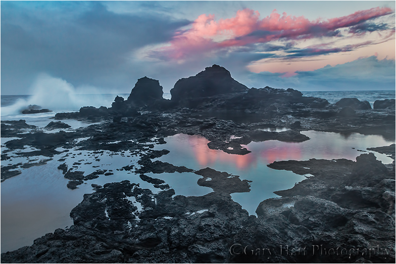
Sunset on the Rocks, West Maui, Hawaii
Canon Rebel EOS SL1
.8 seconds
16 mm
ISO 200
F11
March 2013
On my September scouting trip for my just completed Maui workshop I hiked cross-country down the rugged flank of West Maui, searching for lava-rock tide pools I’d read about. Scrambling down a steep hill and over sharp rocks, I found the beach but decided it was too dangerous for a group. Rather than return the way I came, I continued picking my way along the shore and eventually found another spot I liked better. At first I thought this wouldn’t be suitable for a group either, but climbing out I found an overgrown dirt road/trail leading back to the highway (“highway” in this case is the one-and-a-half lane, mostly-paved, rental-agreement-voiding Highway 340 circling West Maui). Fearing I’d miss this obscure spur from the main road, I saved its position on my GPS.
Last Sunday, the day before the workshop started, I picked up Don Smith (Don assisted this workshop; I’ll return the favor for Don’s Northern Arizona workshop next week) at the airport and was excited to share with him the spot I’d “discovered” (it’s not as if I’m the Edmund Hillary of landscape photography—there’s enough debris down there to indicate the spot is known to locals) and off we went. The steady rain that had been falling for most of the afternoon increased with the road’s remoteness and soon we were slaloming around boulders dislodged from the surrounding cliffs by the downpour—at one point we passed a car waylaid by a grapefruit-size rock embedded in its windshield.
Undeterred, we soldiered on through the intensifying rain. This was Don’s first Maui visit, so I narrated the tour with vigor, enthusiastically pointing out the island’s scenic highlights as we passed them, pausing only occasionally to reassure Don that the highway was navigable despite increasing evidence to the contrary, punctuating my confidence with, “And just wait until you see the scene at the end of this ‘secret’ road I discovered.”
Closely monitoring my GPS, at the prescribed location and without hesitation (for dramatic effect) I veered left into a gap in the trees almost as if I had a brain. The narrow track unfolded between rapidly oscillating wipers, immediately plummeting the steep hill and twisting right. Dense foliage brushed both sides of the car, which by now was clearly losing purchase in the mud. Don hadn’t quite finished a sentence that started, “Are you sure…,” when it started to dawn on me that I’d never intended to actually drive this road, that my plan when I marked it six months earlier was to park at the top and walk down. Oops.
Propelled by momentum, and without the benefit of traction, completely at gravity’s mercy, we careened down the hill (remember the jungle slide scene from “Romancing the Stone”?). Steering seemed to have more influence on the direction the car faced than it did on its direction of travel and I quickly gave that up. If it weren’t for the deep ruts that occasionally nudged us back on course, I’m sure we’d have bounced into the jungle. I held my breath as we approached a protruding boulder and exhaled when the undercarriage passed above unscathed. Shortly thereafter the slope moderated somewhat and I nursed the car to a stop, miraculously still on the “road” (more or less).
After a few seconds of cathartic expletives, Don and I scanned our surroundings. Backing up the slippery road was out of the question, but a little farther down the slope we spotted a flat clear space with a small Y-spur that might enable us to turn around. I scrutinized the dash for the switch that would engage the 4-wheel drive (I swear) the guy at rental agency promised my SUV had. When we didn’t find it Don dug the manual from the glovebox—apparently 4WD is an option the powers-that-be at Alamo deem unnecessary on Maui. Uh-oh.
With crossed fingers I gave the car some gas and felt the wheels spin with no effect. More expletives. Don and I exited into the rain to survey our predicament—the road was fast progressing to creek status, and where rubber tires were supposed to be were instead four mud disks. Hmmm—that would explain the whole no traction thing. Scraping the tires clean would have been of little value because the next revolution would simply reapply a new layer.
Back in the car I found that cranking the wheels 90 degrees gained just enough traction to free us and I gingerly rolled the car downhill and onto the open space. Yay! Once on level ground, and with only a little bit of slip/slide drama, I pivoted the car into the Y and turned around to face the direction we’d just come. Now for the hard part. Looking for the first time toward freedom, we came to grips with the chute that had deposited us: Not only was it steep, at the steepest point it curved hard-left, but banked hard-right—not exactly a design that would be embraced at Daytona.
I inhaled and goosed the gas—we shot upward, fishtailing like a hooked marlin before losing momentum and coming to a stop a mere fifty feet closer to freedom. This time the car was skewed 45-degrees to the road, its left-front fender in the shrubs on one side, its right-rear fender in the shrubs on the other. When I gave the car gas the tires spun hopelessly.
Facing defeat we started strategizing Plan B—with an hour of daylight remaining and no cell service, we’d need to walk up to the highway and hope to flag down in the rain a good samaritan willing to drive two disheveled, mud-caked strangers back to civilization (about 45 minutes away), then hope to summon a tow truck that would extricate us.
While Don trudged up to the main road, I stayed with the car, licking my wounds and feeling pretty foolish. Sitting there it occurred to me that since the road was too narrow for a tow truck, and the distance and tight curve would make winching difficult, even a tow truck wouldn’t guarantee freedom. Watching Don head back up the hill to seek help, I decided to give extraction one more shot. I put the car in reverse gave it more gas and cranked the steering wheel back and forth violently until the tires broke free. So far so good. I took my foot from the brake and let gravity and the rutted road return me to the clearing. Once there, I gave the pedal a gentle nudge in reverse and made it all the way to the back side (another 20 feet) where there might be a little more gravel and less mud, and most importantly, a little more room to gather momentum.
With a small prayer I slipped the transmission into in first and floored the accelerator, rocketing forward with enough forward speed to avoid much of the fishtailing I’d experienced earlier. Past the crumpled shrubs and protruding rock I shot. As the road steepened my momentum slowed and I could feel the wheels spinning but I just kept my foot to the floor. Approaching the curve I felt the car start to tilt right and slow almost to zero but somehow the tires maintained just enough grip to avoid a complete stop. I rounded the curve and surprised Don, who retreated up the road and turned to cheer me forward. By now the fishtailing exceeded the forward motion but I didn’t care as long as there was still forward motion. A short distance beyond the curve the road leveled and much of the mud turned to rock—I was free! Not wanting to stop until my tires kissed pavement I lowered my window and high-fived Don as I shot past and onto the highway. At the top we just couldn’t stop laughing, both at the foolish predicament I’d created, and our utter disbelief that we’d made it out.
Returning to the scene of the crime (March 2014)
Despite the memories, I’ve added this location to my Maui workshop rotation. In my 2014 workshop I took the group here on our final sunset before heading to Hana. Walking down the road this time I still couldn’t believe I’d attempted to drive it at all, let alone in a pouring rain. (I’ll never completely understand how we managed to get out of there.)
But anyway…. The group quickly scattered and I found myself over on the far side of the point with several others. Dark clouds scooted overhead, intermittently dumping rain that sent us scurrying to nearby sheltering rocks before stopping as quickly as it started. Between showers I worked on compositions that featured reflective pools sheltered from the crashing surf by volcanic rocks, hoping for a colorful sunset that would reflect in the smooth water. Given the predominant cloud cover I wasn’t particularly optimistic, but spent my wait-time working out compositions just in case.
This was my first shoot with my backup camera, the amazingly compact Canon EOS SL1 (pressed into service after my 5DIII did a Greg Louganis into a creek in the Iao Valley that morning). Not only was I able to take advantage of the relatively static conditions to craft compositions for later, I was able to use the time to familiarize myself with this camera that I’d only used once before.
So I was ready when, much to my surprise and pleasure, the sun broke through just in time to paint the horizon pink, I was ready. I clicked a number of frames of the various compositions I’d found earlier, timing each with the crashing surf and varying my shutter speed for different wave effects.
Join me in my next Maui photo workshop—we’ll visit this spot, Haleakala, Hana, and a lot more.
Comet Dreams Fulfilled
Posted on March 13, 2013

Comet PanSTARRS & New Moon, Haleakala, Maui
(The moon was a thin crescent; because of the extra light my camera took in, it “saw” lunar detail in the shadow.)
Canon EOS 5D Mark III
3 2/3 seconds
F/5.6
ISO 1600
320 mm
I’ve been a huge comet geek since I was ten years old (details here), so when I heard about Comet PanSTARRS almost a year ago, I was pretty excited. I became even more excited when I learned that PanSTARRS would be a little more than three degrees left of a new moon on March 12. Checking my calendar, I discovered I’d be on Maui for a workshop that week. Sweet.
Fast forward to March 12: I’m on Haleakala, the location of the PanSTARRS telescope that discovered the comet, with my Maui workshop group. After a sunset that colored the swirling clouds in all directions, the clouds close in and completely shut down the sky. We stick it out for a while, but when the cold saps the group’s enthusiasm (it’s 35 degrees with 35 mph winds), I reluctantly honor their wishes. Could I really have gotten so close to this event I’ve been anticipating for nearly a year, only to be denied. Descending the mountain with one eye on the sky, I hope for a break.
Less than two miles down the road we suddenly pop into the clear and see a thin slice of moon dangling like a Christmas ornament in the blue/orange band separating day and night. While PanSTARRS isn’t bright enough to be visible the twilight, I know I can use its proximity to the moon to guide my lens. I pull the car over and we yank out our cameras and start firing, wider shots at first, then tighter to zero in on the comet and moon. As a bonus, the amount of light necessary to reveal PanSTARRS also exposed exquisite detail in the moon’s shadow area.
I’ll write more when I have time but I just had to share. Now, off to Hana….
More Comet Images (mostly NEOWISE)


Later that same morning…
Posted on March 1, 2013
Moonset, Mt. Whitney and the Alabama Hills, California
Canon EOS-5D Mark III
24-105L
1/2 second
F/11
ISO 100
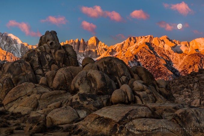
It’s fun to browse the thumbnails from a shoot in chronological order to see the evolution of that day’s process. While can’t always remember specific choices, it’s always clear from the progression of my images that I was indeed quite conscious of what I was doing. I can look at one thumbnail and usually predict what the next will be.
This January morning in the Alabama Hills started for me about forty-five minutes before sunrise. When the sun finally warmed Mt. Whitney, a 95% waning gibbous moon was about to dip below the Sierra crest; comparing images, it’s clear I’d moved no more than twenty feet from the location of that morning’s earliest images. This is pretty typical of my approach—unlike many (but not all) photographers, who actively bounce around a location in search of something different, I tend to seek the scene until I find it, then work it to within an inch of its life. If I’m moving around, it usually means I haven’t found something that completely satisfies me.
Is mine the best approach? Of course not, but it is the best approach for me. There is no all encompassing rule for workflow in the field, except maybe to be true to your instincts. Because I happen to be very deliberate in my approach to many things, and can be incredibly (obsessively?) patient when I sense the potential for something I want, that’s the way I shoot. But, regardless of changing conditions and possible compositional variations, some photographers would go crazy locking into one scene. And just as my deliberate approach continually reveals details I’d have missed had I moved on sooner, it sometimes cheats me of even better opportunities waiting just around the corner. But I learned a long time ago not to stress about what I might be missing (because for me it’s even worse to chase what’s around the corner only to find what I end up with doesn’t match what I left).
Early on this chilly morning I found a relationship between a nearby stack of boulders and the distant Sierra peaks (Mt. Whitney in particular); the more time I spent with the scene, the more I saw and the better all the elements seemed to fit for me, so I just kept working. It didn’t hurt that conditions were changing almost as quickly as I could compose. Clouds ascended from behind Mt. Williamson as if churned out by a cloud making machine, sprinted south past Mt. Whitney, and disappeared behind Lone Pine Peak. On their way they took on whatever hue the rising sun was delivering, from white (before the sun) to vivid pink to amber.
Comparing today’s image to the image in my previous post, I see that my composition shifted to account for the moon. In the earlier image the most prominent boulder and Mt. Whitney serve as a set that anchors the center of the frame. In the later image I keep the set together but offset them to the left to balance the moon’s extreme visual weight. And while at first glance it appears both images were captured from the same spot with just slight focal length and direction adjustments, the height and position of the foreground boulder relative to Mt. Whitney’s summit shows that I’ve moved a little left and about twenty feet closer.

Before Sunrise, Mt. Whitney and the Alabama Hills, California
Relationships between elements in a frame are essential to an image’s success—controlling these relationships is a matter of moving up/down, left/right, forward/backward. Without remembering my decision to move that morning, I can still reconstruct my likely thought process: The more I worked the scene, the more clear I became on where the boulders’ left and right boundaries should be. Moving left and closer let me go wide enough to include the moon and clouds, fill the foreground with no more of the foreground boulders than I wanted, and balance the frame with the boulder/Whitney pair on the left and the moon on the right.
So while I do indeed stick with one scene for a long time, I’m far from static. Each frame is slightly different from the previous one. Like most of my favorite images, this Whitney sunrise moonset is an evolution; it started in the dark, evolving with the conditions and my growing familiarity with the scene’s elements.
There are no guarantees in nature, and I’ve had my share of “panic shoots” when something unexpected forced me to run around frantically searching for a scene to go with the moment. But when this morning’s dance of light, clouds, and moon blended into one of those magic moments photographers dream about, I was ready.
Photo Workshop Schedule
An Eastern Sierra Gallery
Click an image for a closer look and slide show. Refresh the screen to reorder the display.


The secret world before the sun
Posted on February 24, 2013
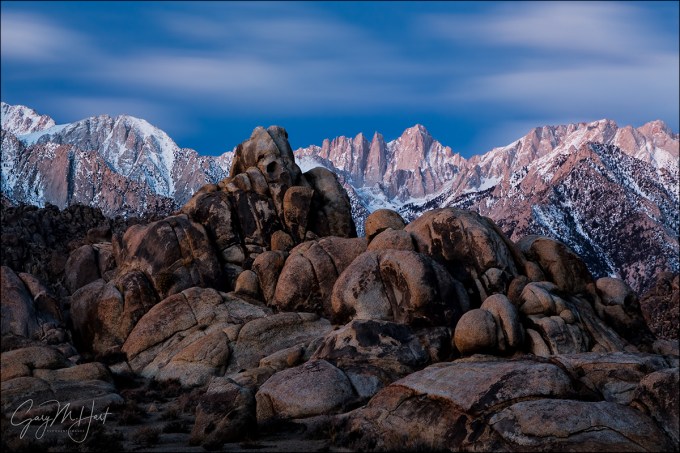
Before Sunrise, Mt. Whitney and the Alabama Hills, California
Canon EOS 5D Mark III
30 seconds
F/16
ISO 400
70 mm
Compared to the human eye, the camera’s vision has many shortcomings (as photographers are quick to lament). At the top of photographers’ list is the very narrow gap separating the brightest and darkest tones a camera can capture: dynamic range.
But while the camera taketh away, it also giveth. Experienced photographers understand that what we perceive as complete darkness is really just our eyes’ relatively limited ability to gather light, combined with the brain’s insistence on processing this limited input instantaneously. But a camera’s sensor (or a rectangle of unexposed film) can accumulate all the light striking it for whatever duration we prescribe, thereby stretching its “instant” of perception indefinitely. Advantage camera.
For example, the camera’s narrow dynamic range is (exquisitely) mitigated in the barely perceptible light preceding sunrise and following sunset. Unlike night photography, when the light in the sky is so faint that extremely long exposures are required to register any foreground detail, and daylight/moonlight photography, when unidirectional light casts high contrast shadows that exceed a camera’s dynamic range, pre-sunrise/post-sunset twilight light is spread so evenly overhead that most shadows disappear.
About this image
Horizon-to-horizon skylight made dynamic range a non-factor in the above Alabama Hills pre-sunrise scene, while my camera’s instant-stretching ability revealed beauty present in a landscape that was nearly invisible to my eyes.
I arrived at this scene about 45 minutes before sunrise, but knew from experience I wasn’t too early to get to work. White with snow and towering 10,000 vertical feet above my location in the Alabama Hills, Mt. Whitney jutted in dramatic contrast to the dark sky. As my eyes adjusted to the limited light, the jumbled rocks of the Alabama Hills became vague, colorless shapes. Anyone relying on their eyes on this January morning would likely conclude that there’s not yet enough light for photography. But I knew better.
I started by juxtaposing a nearby fortress of boulders against Whitney’s serrated outline. While the mountains were the dominant feature to my eyes, I knew a long exposure would make the nearby rocks equally prominent, making their sharpness essential. Limited light made autofocus out of the question, so I stopped down to f16 to increase my margin for error and focused manually.
As expected, a thirty-second exposure at ISO 400 uncovered volumes of invisible detail and color my eyes missed. (It took two or three exposures to get the focus, exposure, and composition right, as I felt like I was working blind, and my meter was of little value in the darkness.) Though I was photographing in a fairly stiff (and frigid!) breeze at 4,500 feet, it was nothing like the hurricane wind that smeared the clouds above Whitney into an ethereal glaze. Another revelation of the long exposure was the sky’s exquisite, natural (not processing-enhanced) blue-hour hue.
Workshop Schedule || Purchase Prints
A twilight gallery
Click and image for a closer look, and to enjoy the slide show


Sandstorm
Posted on February 19, 2013
Sandstorm, Mesquite Flat Dunes, Death Valley
* * * *
Read my February 9 blog for more about this amazing evening on the dunes.
____________________
For nearly an hour my workshop group played in relative peace on the dunes, but about fifteen minutes before sunset the clouds dropped and our window of calm slammed shut. Just like that sand was everywhere, invading every camera, clothing, and exposed body orifice. After a few minutes of extreme photography packed up and started traipsing in the diminishing light in the general direction of the highway. Not only was the visibility limited, the tracks we’d just left and that might have guided us back to the cars had already been all but erased. But despite the difficulty it was impossible to ignore the photo opportunities brought by these new conditions and most in the group continued shooting until we were off the sand.
Looking east I saw the crest of Red Top, the tallest of the Death Valley Buttes, poking through the blowing sand, hovering like a spaceship above the dunes. I moved around a bit until I found a complementary foreground of aligned ripples and curved ridges. Wanting to ensure that the exquisite sand at my feet was sharp I closed down to f16; to capture the steady stream of sand blowing parallel to the dunes I experimented with ISO/shutter combinations before finding the effect that worked. (And said a prayer of thanks to Gitzo and Really Right Stuff for keeping everything stable.)
Contrast the color of the sand between this image and the image in my February 9 blog. The earlier image was partially warmed by rays of unfiltered sunlight breaking through gaps in the clouds; today’s image is entirely illuminated by cool, diffused light spread by the thick clouds overhead. It’s a good reminder that color isn’t simply an inherent quality of an object, but rather is a function of the object and the light illuminating it. While white balancing a scene to ensure a fixed color cast might be great for a wedding (God forbid you get Aunt Mabel’s dress wrong), it can rob landscapes of the very qualities that make them special.

Join my next Death Valley photo workshop
Greetings from Squirrel Rock
Posted on February 14, 2013

Sunset Reflection, El Capitan and Horsetail Fall, Yosemite
* * * *
Every workshop has its inside jokes, some comment or reference that gets everyone laughing and somehow seems to find its way into every location or mealtime conversation. So today I offer this beautiful reflection of Yosemite’s Squirrel Rock. Often mistakenly referred to as “El Capitan,” this frequently photographed granite monolith…. Okay, okay, I know, I know, this really is El Capitan, but for the duration of my just completed Yosemite Winter workshop our group affectionately referred to this Yosemite icon as “Squirrel Rock.”
Huh? It seems that my friend Don Smith, who was assisting me in this workshop (I’ll return the favor by assisting Don’s Northern Arizona workshop next month), was photographing at Tunnel View the day before the workshop when a man approached and introduced himself as a fellow pro photographer, then proceeded to position himself as a Yosemite-expert extraordinaire. As if to make his point, he went on to tell Don and all who would listen that the rocks above Bridalveil Fall that we all know as Cathedral Rocks are in fact the “Three Graces.”
In all fairness, the Tunnel View perspective of Cathedral Rocks was once upon a time called the Three Graces (I haven’t heard this reference in years); if he’d have stopped at that all would have been fine and his audience might have learned something. Our amusement was fuel by his adamant insistence, delivered with professorial authority (picture Cliff Clavin), that this ancient Three Graces label (and ignoring National Park and USGS topo maps to the contrary) means the rock formation above Bridalveil Fall cant’ be Cathedral Rocks. That his proclamation was uttered almost literally in the shadow of a National Parks Service sign labeling said icon Cathedral Rocks seemed no deterrent.
Fast forward to workshop Day-1: Don shared his story with the group at Tunnel View, finishing with a grand wave in the direction of El Capitan and telling us all in Clavinesque fashion that its true name is Squirrel Rock. It wasn’t long before Yosemite Falls became Kangaroo Falls, and with these new monikers grew Native American legends of their origins and…, well let’s just say that a workshop’s worth of laughter ensued.
If all this sounds a little silly, please understand that the workshop’s prime objective was Horsetail Fall, a February phenomenon with far more photographers than room to photograph. To ensure a front row seat at the best spot, for two nights in a row we queued up at my favorite vantage point beside the Merced River two hours before sunset. That’s a lot of waiting (and story swapping, and joking, and embellishing, and just plain frivolity).
Our time passed quickly, and while (if the goal is the classic Horsetail blood red sunset stripe) neither night will go down in the annals of Horsetail Fall photo moments, we were nevertheless rewarded with some magnificent photography. On Monday billowing cumulus clouds decorated Squirrel Ro…, uhhh, El Capitan and reflected in the Merced River. Tuesday night we almost hit a home run, but as we rounded third, thin clouds unseen on the western horizon dulled the setting sun and we had to settle for a stand-up triple. Very nice nevertheless.
Both evenings were a blast, well worth the waiting, both for the photography and the good time. Because I already have my tight Horsetail Fall shot from this spot, and the highlight of the first evening was the clouds and reflection, I opted for the wide composition you see above. This location has far more compositional options than the popular El Capitan picnic area spot (which has more room). In fact, even though Horsetail didn’t perform to perfection, both evenings we had things to photograph for the duration of our wait. At one point the tree on the shore at the right of the frame lit up like it had been hit by a spotlight, and Sentinel Rock, directly behind and above us, spent much of the afternoon bathed in warm light.
It seems every workshop has something memorable to set it apart from all the others. In this case it was night after night of warm light and crisp reflections, plus a large dose of laughter. Long live Squirrel Rock.
Pure as the driven sand
Posted on February 9, 2013

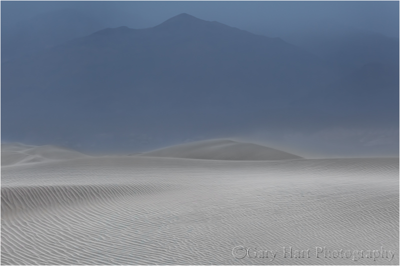
Storm Brewing, Mesquite Flat Dunes, Death Valley
Canon EOS-5D Mark III
21 mm
1/6 second
F/22
ISO 400
February 2013
Sand dunes’ graceful curves and intricate textures move and intrigue the eye, and few things better convey nature’s purity than a windswept dune. Ironically, it’s the dunes’ aesthetic magnetism that hastens their demise as photographic subjects—their fragile sand, so easily sculpted by Mother Nature’s fickle winds, is hopelessly marred by any contact with the humans drawn by their beauty.
While Death Valley has several sets of dunes, by virtue of their ease of access, the most popular by far are the Mesquite Flat Dunes near Stovepipe Wells. Every day hundreds (thousands?) of gawkers seeking a closer look trudge up and down the undulating sand—with each footstep a small amount of purity is lost. Fortunately, it’s rarely long before Mother Natures has had enough and sends in scouring winds that erase the scars like a shaken Etch-A-Sketch.
This year’s Death Valley workshops landed in the middle of an extended static without significant wind, so I knew pristine sand would be hard to find. To minimize the footprints I take my groups to a spot that’s away from the tourist foot traffic, but this time I knew that wouldn’t be enough. Nevertheless we gave it a shot and managed to find enough patches of untouched sand to isolate with a telephoto and everyone was satisfied. Except me.
So when a stiff wind kicked up the afternoon of our final full day in Death Valley I took them back out to the dunes with fingers crossed. On our drive from Furnace Creek the cars were buffeted by gusts and the entire northern horizon was obscured by dark clouds that I soon realized were in part blowing sand—a very good sign indeed. I pulled up to a spot I’d scouted a few days earlier, far removed from the paved parking area and tall dunes that draw people, and surveyed the conditions. The wind whipped anything not buttoned down and pewter clouds were rapidly overtaking the late afternoon light skimming the Cottonwood Mountains.
The group prepared for strong wind and blowing sand similar to the way we’d prepare to photograph in the rain, but in the five minutes it took to get onto the dunes the wind had mysteriously diminished to an eery calm. Before us spread pure, rippled sand for as far as the eye could see. And except for one distant photographer who quickly passed out of sight, we were the only people out there.
Fearing a shotgun approach to setting the group free would result in inadvertent footprints marring the scenes of others, I gathered everyone and suggested that we move together and agree to stay behind a predetermined imaginary line. The problem, I explained, wasn’t just staying out of everyone’s frame, it was that each step in the sand would ruin all shots in that direction. So they all followed me until I found a nice scene with a good amount variety, which we all photographed for a few minutes before I guided them to another scene. After two or three of these cycles, it seemed everyone had become comfortable enough with the environment and the ground rules that we could scatter without interfering.
I have to say that there is no kind of photography that makes me happier than what we did that evening. With virgin, textured sand and a dramatic, rapidly changing sky, the creative possibilities were off the charts. Surveying the group, it was clear that everyone was as thrilled as I was, each fully engaged in their own photographic zone. I kept telling them that they had no idea how lucky they were to be photographing these dunes without a single footprint, but I’m not sure anyone was listening at that point.
About this image
Most successful images provide a clear path for the eye to follow, or an obvious place for the eye to rest—often both. With sand dunes, so much visual motion (curves and lines) and activity (texture) makes a visual resting point particularly important. The first place I stopped the group was in front of this solitary shrub atop a low, curving ridge of sand. The scene had all the compositional elements you could ask for: elegantly arcing sand, rich texture, a dramatic sky, and a potential focal point. After pointing all this out and encouraging the group to assemble the key elements into a composition that resonates with them, I was pleased to see lenses of all focal lengths, horizontal and vertical compositions, and lots of repositioning to arrange foreground and background relationships.
Surveying the scene for myself, I noticed clouds moving in from the north painted a texture overhead that complemented the ridged sand at my feet. The filtered sunlight on the western horizon, while waning, was still sufficient to warm the scene. Finding the sand and sky equally appealing, and the shrub more interesting for its lofty perch than its inherent beauty, I tried to identify a composition that incorporated these elements.
To emphasize the foreground and sky, and to shrink the shrub, I twisted on my widest lens and dropped to about a foot above the sand. A vertical composition allied the dune’s parallel ridges with the frame’s long side to move the eye from front to back and created the impression that the entire world is converging on my little shrub. The vertical composition also narrowed the frame enough to eliminate incongruous clouds lowering on my left and right. I stopped-down to f22 and focused about three feet in front of my lens, ensuring perfect close sharpness and acceptable distant sharpness. A soft breeze swayed the shrub intermittently so I bumped to ISO 400 to allow a faster shutter speed.
In typical Death Valley fashion, it never did rain that evening. As the storm approached, all menace and bluster, our cocoon of calmness soon gave way to sand-whipping, tripod-tipping winds that lowered a cloudy shroud onto the Death Valley Buttes and Funeral Mountains to the east, cooling the light and creating an altogether different mood (that I’ll share in a future post).
Workshop Schedule || Purchase Prints
A Death Valley Gallery
Click an image for a closer look, and a slide show. Refresh your screen to reorder the display.


Death Valley Winter Moon Photo Workshop
The Road to the Racetrack, Part Deux
Posted on January 31, 2013

Last Light, The Racetrack, Death Valley
* * * *
Previously on “The Road to the Racetrack”
Racetrack Road approaches from the north and skirts the west side of Racetrack Playa in the shadow of Ubehebe (yuba-he’-be) Peak. We crested the saddle above the playa’s north perimeter and dropped out of the gray soup that had confined our world for about two hours. Before us spread the entire Racetrack Playa, its surrounding mountains draped in clouds that cascaded down their slopes like slow motion waterfalls. The light rain that had barely required windshield wipers stopped completely. Descending the saddle’s south side into the basin, our view was monopolized by the Grandstand—a cruise ship size chunk of adamellite (a dark, igneous intrusive rock similar to granite) jutting from the paper-flat playa. This is what the submerged portion of an island looks like. As we rolled past I couldn’t help thinking that the Grandstand would be a far more sought-after subject were it not for the moving rocks that take top bill here.
As much as I’d loved to have stopped to photograph the Grandstand, it was late afternoon and I was anxious to locate the main attraction before the good light came and went. The drive to the south side of the Racetrack is just one mile, but the road’s extreme washboard surface is a natural speed inhibitor; every time my speedometer nudged toward fifteen miles per hour our SUV started bouncing like an off-balance washing machine and I had to back off. Doug, Jay, and I had chuckled when the Stovepipe Wells grocery clerk told us that the rocks had mysteriously disappeared from the Racetrack, but I’ll admit to taking advantage of our slow speed to (anxiously) scrutinize the playa as we skirted its perimeter—what if it was true? Vibrating along, I saw a couple of grapefruit-size rocks trailing short tracks just west of the Grandstand, but nothing like the rocks we’d come for.
We finally stopped at the playa’s extreme south end where a couple of photographers were photographing a handful small rocks just a couple of hundred feet from the road. These rocks just didn’t seem natural to me—partly because of the nearby tire tracks marring the playa’s surface (the selfish ignorance of humans in nature never fails to disappoint me) and partly because they were so far from any rock source (these things don’t just drop from the sky). Standing there on the playa’s southwest edge, it was clear that the rocks we sought could only originate from the base of the steep mountain abutting the southeast corner. And indeed, looking more closely in that direction, we could just make out a large accumulation of black dots that could only be rocks. The playa’s utter flatness can be disorienting, but given that the Racetrack stretches one mile on its long, north-south axis, I estimated that the east side was about a half mile away. So off we set.
The playa’s color and chalky dust reminded me of a flour tortilla; its surface is a jigsaw of round polygons about three inches in diameter, separated by shallow cracks that have been filled in by the fine dust. When dry like this (there was no noticeable accumulation of the nearby rain) it’s an easy surface to walk. After ten minutes we arrived at the first rocks, toaster- to microwave-size, each with its own straight, curved, or zig-zag track. Eureka! We immediately spread out, claimed a specimen of our own, and went to work. Initially the best light was on the southwest horizon, where a hole in the clouds, obscured by Ubehebe Peak, passed enough sun to illuminate the low overcast (see the image in my previous post).
Soon our attention was drawn to the playa’s north end, toward the Grandstand, where a shaft of golden light had started skimming the dark hills and firing up the clouds there. I quickly circled the rock I was working on to swing my camera in that direction. As the shaft warmed it stretched further, eventually extending from edge to edge. As the light seemed to reach a crescendo Doug, who was set up about a hundred feet away, called out, “That almost looks like a rainbow.” I looked closer and sure enough, there was indeed a (quite faint) prism of color splashed above the sunlit hills bounding the playa’s northeast edge.
The one frame with my polarizer properly oriented for the rainbow that I managed to get off is at the top of the post. You have to look closely to see the rainbow (it’s there, I swear); careful examination reveals that the rainbow moves from green on the outside (left) to red on the inside (the shorter wavelength colors that would be left of green aren’t visible), meaning that our angle of view only gave us the fainter, outer band of a double rainbow. By the time I’d set up my next composition the light faded and with it the rainbow. Visions of a full rainbow arcing above the Racetrack dashed, we nevertheless couldn’t help feel that we’d been granted a very rare treat in this land of interminable blue sky.
The rest of our trip, though not without its moments, was anticlimax. After sunset we walked back to the car and ate dinner (soggy sandwiches for Jay and me, ramen noodles for Doug-the-chef), then went back out in the dark for a moonlight shoot without stars. By then the clouds had thickened and dropped, making it difficult to get anything that really looked like night. After a very restless night (one hour awake for every hour asleep for me), we rose for “sunrise” (or more accurately, “fogdrop”). While not quite spectacular, the low clouds swirling above the playa, spilling down the mountains in the thin light no doubt gave us unique images (that I haven’t had time to get to). And on the drive back we were able to see the terrain that had been completely obscured by clouds on our inbound trip, the highlight of which was several miles of joshua tree forest we’d been completely oblivious to earlier. In fact, despite my extreme need to be back in Furnace Creek in time for my workshop (that started at 1:00 that afternoon), at one point we encountered a scene with nearby joshua trees juxtaposed against distant, fog-wrapped mountains that we couldn’t help stopping to shoot for fifteen minutes or so.
After depositing Jay at his car in Stovepipe Wells, Doug and I made it back to Furnace Creek by 11:45 and managed to clean up, have lunch, and set up for orientation with time to spare. Piece of cake.
The Road to the Racetrack
Posted on January 28, 2013

Sliding Rock, The Racetrack, Death Valley
* * * *
A couple of weeks ago I got the bright idea to spend the twenty-four hours separating my two Death Valley workshops with a trip out to the Racetrack. While it seemed like such a good idea at the time, as my first workshop drew to a close I started longing for a bit of recharge time before the next one (it didn’t help that the first workshop’s final night was in Lone Pine near Mt. Whitney, an hour-and-a-half drive from Death Valley). But since I’d invited my brother Jay (who assisted my first workshop) and friend Doug (who would assist my second workshop), and they’d changed plans to join me, I sucked it up and made the trip (much to my ultimate delight).
You’ve probably seen pictures of the Racetrack, which, like many features in Death Valley, defies common logic. The Racetrack is a perfectly flat playa (dry lakebed) surrounded by rocky mountains that frequently shed large chunks of dolomite, many of which come to rest on the playa surface. But unlike the rocks you and I have known, the Racetrack rocks move. A lot. And as they scoot along the playa they carve tracks in the otherwise flat surface, sometimes several hundred yards long. The creepiest thing is that nobody has actually seen these rocks move. Science still doesn’t have a perfect explanation for what goes on here, but the general consensus is a combination of water, wind, and (possibly) ice is involved.
A major part of the Racetrack legend is the road out there. It’s a two hour drive on twenty-seven unpaved, unpatrolled miles of sharp rocks and jarring ruts. The road, a notorious tire eater, twists up to 5,000 feet elevation before dropping back down to 3,700 feet at the playa.
Given the time and effort it takes to get to the Racetrack, our plan was to land in time photograph sunset, wait for dark and photograph by moonlight, then throw down sleeping bags and spend the night, rising early enough to photograph sunrise. Armed with my rental SUV, if all went as planned (no flat tires), we’d make it back to Furnace Creek by noon and (fingers crossed) have time to clean up and eat lunch before starting workshop number two at 1 p.m. Piece of cake.
So, at the conclusion of workshop number one, my brother and I hustled back from Lone Pine and picked up Doug in Stovepipe Wells. Before setting out we made a quick stop in the general store, where the clerk reported that a recent Racetrack visitor had told him earlier that day that all the rocks had been stolen. Hmmm. Undeterred, we set off on our adventure with high hopes.
A light rain fell for much of the drive, quite unusual in this arid region that gets less than two inches of rain per year. And with rain comes clouds, one of which we entered not long after turning onto Racetrack Road. Instantly the visibility dropped to about one hundred feet and remained that way for much of the journey. Of course the lack of a view was of little concern to me, since my eyes strayed from the road only long enough check the dashboard tire pressure indicator.
Given the limited visibility and my targeted focus, I’m afraid I have little to report of the journey, except that it was with great relief that we somehow pulled up to the playa on schedule and without consequence. The rest of our adventure will need to wait until my next post—until then, above I offer proof that we did indeed make it, and that the trip was very much worth the effort.

